IMAGES TAKEN NEAR TO
Honicknowle Lane, PLYMOUTH, PL5 3NE
Introduction
This page details the photographs taken nearby to Honicknowle Lane, PL5 3NE by members of the Geograph project.
The Geograph project started in 2005 with the aim of publishing, organising and preserving representative images for every square kilometre of Great Britain, Ireland and the Isle of Man.

There are currently over 7.5m images from over14,400 individuals and you can help contribute to the project by visiting https://www.geograph.org.uk
Image Map
Images are licensed for reuse under creativecommons.org/licenses/by-sa/2.0
Notes
- Clicking on the map will re-center to the selected point.
- The higher the marker number, the further away the image location is from the centre of the postcode.
Image Listing (16 Images Found)
Images are licensed for reuse under creativecommons.org/licenses/by-sa/2.0
Image
Details
Distance
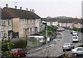
2
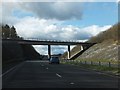
Bridge over the Parkway
Plymouth Parkway, a new road to take traffic from across the city from the eastern edge to the Tamar Road Bridge, was set out in the 1943 "Plan for Plymouth" a document which shaped so much of post-war Plymouth. The Parkway was not actually built until the 1980's.
Image: © Tony Atkin
Taken: 7 Jan 2006
0.12 miles
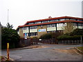
3
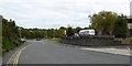
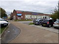
Burrington Way, Plymouth
This is the access road for a small industrial estate on the north of Plymouth
Image: © David Smith
Taken: 26 Sep 2014
0.14 miles
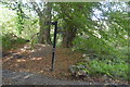
4
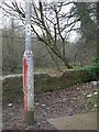
How much graffiti can a lamppost take?
This lamppost is near a nature reserve, seen in the background of the photograph. It is also close to a school.
Image: © Tony Atkin
Taken: 7 Jan 2006
0.15 miles
6
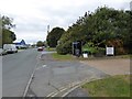
Burrington Way and sign for the Co-operative Way
Burrington Way is the main road for a small industrial estate on the site of Burrington Farm. The sign points to a narrow path between fences which is part of the Co-operative Way, a circular walk around north Plymouth
Image: © David Smith
Taken: 26 Sep 2014
0.17 miles
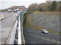
8

A38 Plymouth bypass, in a cutting near Honicknowle
Image: © David Smith
Taken: 26 Sep 2014
0.19 miles