IMAGES TAKEN NEAR TO
Row Lane, PLYMOUTH, PL5 2EF
Introduction
This page details the photographs taken nearby to Row Lane, PL5 2EF by members of the Geograph project.
The Geograph project started in 2005 with the aim of publishing, organising and preserving representative images for every square kilometre of Great Britain, Ireland and the Isle of Man.

There are currently over 7.5m images from over14,400 individuals and you can help contribute to the project by visiting https://www.geograph.org.uk
Image Map
Images are licensed for reuse under creativecommons.org/licenses/by-sa/2.0
Notes
- Clicking on the map will re-center to the selected point.
- The higher the marker number, the further away the image location is from the centre of the postcode.
Image Listing (9 Images Found)
Images are licensed for reuse under creativecommons.org/licenses/by-sa/2.0
Image
Details
Distance
1
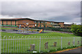
Tamarside Community College - Plymouth
Currently a technology college it is set to become the UK's first Marine Academy in September 2010 putting marine studies at the heart of its syllabus.
Image: © Mick Lobb
Taken: 1 May 2010
0.14 miles
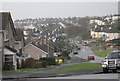
2
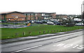
Tamarside Community College
Tamarside is a modern secondary school in the west of Plymouth.
Image: © Tony Atkin
Taken: 7 Jan 2006
0.16 miles
3
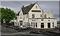
The Fellowship, Trevithick Road - Plymouth
Image: © Mick Lobb
Taken: 1 May 2010
0.20 miles
4
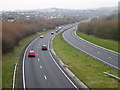
Plymouth Parkway
This road carries the main A38 route through the heart of Plymouth. It was built in the late 1980's although the route had been reserved since 1943 when it was first proposed in Abercrombie and Watson's Plan for Plymouth.
Image: © Tony Atkin
Taken: 7 Jan 2006
0.21 miles
5
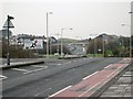
Old Road - New Road
The road in the distance is the Plymouth Parkway which takes traffic through Plymouth and over the Tamar Road Bridge into Cornwall. The Parkway replaced the narrower road in the foreground which has been converted from a dual carriageway to a single carriageway with a cycle lane. The road is clear of traffic but it is in fact very busy. The photographer had to wait about 10 minutes to get this traffic-free shot.
Image: © Tony Atkin
Taken: 7 Jan 2006
0.24 miles
7
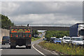
Plymouth : The A38
The A38 Devon Expressway heading through Plymouth.
Image: © Lewis Clarke
Taken: 17 Jul 2015
0.24 miles
8
Footbridge over A38 from Ernesettle Lane
This bridge follows the former route of Ernesettle Lane from the north (right). Traffic on the lane follows the new route, and runs alongside the A38 to a road bridge behind the photographer.
Image: © David Smith
Taken: 18 Mar 2012
0.24 miles
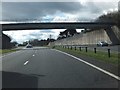
9

Westbound A38, Bridge at St Budeaux Junction
Image: © David Dixon
Taken: 13 Apr 2022
0.25 miles