IMAGES TAKEN NEAR TO
Wolseley Road, PLYMOUTH, PL5 1JQ
Introduction
This page details the photographs taken nearby to Wolseley Road, PL5 1JQ by members of the Geograph project.
The Geograph project started in 2005 with the aim of publishing, organising and preserving representative images for every square kilometre of Great Britain, Ireland and the Isle of Man.

There are currently over 7.5m images from over14,400 individuals and you can help contribute to the project by visiting https://www.geograph.org.uk
Image Map
Images are licensed for reuse under creativecommons.org/licenses/by-sa/2.0
Notes
- Clicking on the map will re-center to the selected point.
- The higher the marker number, the further away the image location is from the centre of the postcode.
Image Listing (79 Images Found)
Images are licensed for reuse under creativecommons.org/licenses/by-sa/2.0
Image
Details
Distance
4
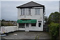
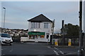
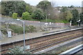
Ferry Road Station St Budeaux
This is a halt on the main line to Cornwall. Few trains stop here although you will often get stuck here for a few minutes on your way to Cornwall while the train waits for another to clear the single line section up ahead.
Image: © Tony Atkin
Taken: 25 May 2008
0.01 miles
5
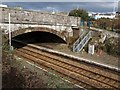
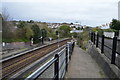
Railway bridge, St Budeaux Ferry Road
The railway bridge shown in Image, seen from the path down to St Budeaux Ferry Road station's westbound platform, with the path to the eastbound platform on the right.
Image: © Derek Harper
Taken: 9 Feb 2010
0.02 miles
10
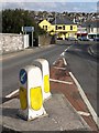
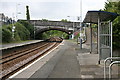
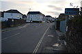
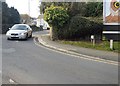
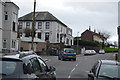
Barne Road, St Budeaux
The road crosses two railway lines in quick succession to leave the Barne Barton estate and reach the shops on Wolseley Road. As the blue notices indicate, this means that the bridge gives access to two different stations on different lines, which must be unusual. On the left is a path to St Budeaux Victoria Road (see Image), on the Tamar Valley Line to Gunnislake, while off to the near right is St Budeaux Ferry Road station (see Image), on the Cornish Main Line. Perhaps that's why there are two road bollards so close together.
Image: © Derek Harper
Taken: 9 Feb 2010
0.03 miles