IMAGES TAKEN NEAR TO
Laira Bridge Road, PLYMOUTH, PL4 9LW
Introduction
This page details the photographs taken nearby to Laira Bridge Road, PL4 9LW by members of the Geograph project.
The Geograph project started in 2005 with the aim of publishing, organising and preserving representative images for every square kilometre of Great Britain, Ireland and the Isle of Man.

There are currently over 7.5m images from over14,400 individuals and you can help contribute to the project by visiting https://www.geograph.org.uk
Image Map
Images are licensed for reuse under creativecommons.org/licenses/by-sa/2.0
Notes
- Clicking on the map will re-center to the selected point.
- The higher the marker number, the further away the image location is from the centre of the postcode.
Image Listing (145 Images Found)
Images are licensed for reuse under creativecommons.org/licenses/by-sa/2.0
Image
Details
Distance
1

The A374
A carload of bikes off to have fun somewhere.
Image: © Robert Ashby
Taken: 4 Aug 2015
0.03 miles

3
Old Boundary Marker on Laira Bridge Road, Plymouth
Municipal Boundary Marker against a metal fence on the northeast side of the A379 Laira Bridge Road, Plymouth, immediately east of its junction with Hele's Terrace. Inscribed F.W. HARRIS / (1892) for Francis W Harris, mayor.
Milestone Society National ID: DV_PCBS42pb
Image: © T Jenkinson
Taken: 31 May 2012
0.05 miles

6
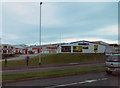
Business park
Business park at Prince Rock.
Image: © Robert Ashby
Taken: 24 Aug 2014
0.06 miles
7

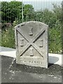
Old Milestone by the A379, Laira Bridge Road, Plymouth
Carved stone post by the A379, in parish of Plymouth (Plymouth District), Laira Bridge Road, by No. 56 and 58 flats, opposite the rear of Prince Rock Primary School, bottom of footbridge, flat in low wall, on South side of road. Embankment stone, erected by the Embankment Company turnpike trust in the 18th century.
Inscription reads:-
1
MILE
FROM
PLYMOUTH
Milestone Society National ID: DV_TNPL21
Image: © T Jenkinson
Taken: 6 Oct 2006
0.07 miles
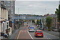
10
Gdynia Way
Gdynia Way (A374) named from the city in Poland twinned with Plymouth
Image: © Shaun Ferguson
Taken: 21 Jul 2009
0.08 miles