IMAGES TAKEN NEAR TO
Maybank Road, PLYMOUTH, PL4 9AU
Introduction
This page details the photographs taken nearby to Maybank Road, PL4 9AU by members of the Geograph project.
The Geograph project started in 2005 with the aim of publishing, organising and preserving representative images for every square kilometre of Great Britain, Ireland and the Isle of Man.

There are currently over 7.5m images from over14,400 individuals and you can help contribute to the project by visiting https://www.geograph.org.uk
Image Map
Images are licensed for reuse under creativecommons.org/licenses/by-sa/2.0
Notes
- Clicking on the map will re-center to the selected point.
- The higher the marker number, the further away the image location is from the centre of the postcode.
Image Listing (59 Images Found)
Images are licensed for reuse under creativecommons.org/licenses/by-sa/2.0
Image
Details
Distance
1

Beaumont Road Post Office, Plymouth.
The image shows the queue on pension day, the week before Xmas 1980. The photo was taken in Maybank Road, on the corner of Beaumont Rd.
Image: © Chris Hoare
Taken: 20 Dec 1980
0.03 miles
2
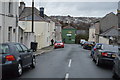
Salisbury Road School Plymouth
Salisbury Road School was built in 1903 and once housed nursery, infant, junior and senior schools. During the First World War it was pressed into service as a military hospital.
Image: © Mick Lobb
Taken: 4 Oct 2008
0.12 miles
3

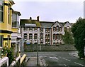
Cleveland Road, Plymouth
This terrace of houses faces Tothill Park in the St Jude's area of the city.
Image: © Derek Harper
Taken: 28 Oct 2006
0.13 miles