IMAGES TAKEN NEAR TO
Salisbury Road, PLYMOUTH, PL4 8QT
Introduction
This page details the photographs taken nearby to Salisbury Road, PL4 8QT by members of the Geograph project.
The Geograph project started in 2005 with the aim of publishing, organising and preserving representative images for every square kilometre of Great Britain, Ireland and the Isle of Man.

There are currently over 7.5m images from over14,400 individuals and you can help contribute to the project by visiting https://www.geograph.org.uk
Image Map
Images are licensed for reuse under creativecommons.org/licenses/by-sa/2.0
Notes
- Clicking on the map will re-center to the selected point.
- The higher the marker number, the further away the image location is from the centre of the postcode.
Image Listing (102 Images Found)
Images are licensed for reuse under creativecommons.org/licenses/by-sa/2.0
Image
Details
Distance
1
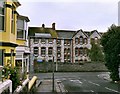
Salisbury Road School Plymouth
Salisbury Road School was built in 1903 and once housed nursery, infant, junior and senior schools. During the First World War it was pressed into service as a military hospital.
Image: © Mick Lobb
Taken: 4 Oct 2008
0.08 miles
2
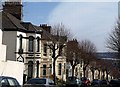
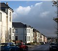
Beatrice Avenue, Plymouth
Like Image, with which it runs almost parallel, this street runs down the hill from Lipson Road. These houses have a little more decoration - and there are more trees.
Image: © Derek Harper
Taken: 27 Mar 2010
0.09 miles
3
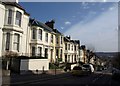
Greenbank Avenue, Plymouth
One of several streets of pleasant canted-bay-fronted terraces, which drop down with dramatic views to Cattewater and beyond.
Image: © Derek Harper
Taken: 27 Mar 2010
0.11 miles
4
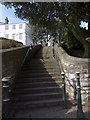
Steps to Freedom Fields
A flight of steps leads from Lipson Road up to the southwest corner of the park. The metal posts match those further up the road shown in Image The white house is on Woodside.
Image: © Derek Harper
Taken: 27 Mar 2010
0.14 miles
6
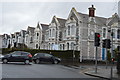
Knighton Road, Plymouth
These terraces with canted bays, bright in the sunshine, face Image The junction is with Greenbank Avenue.
Image: © Derek Harper
Taken: 8 Nov 2008
0.15 miles
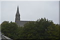
8
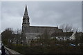
Church of St Jude
Grade II listed. http://www.britishlistedbuildings.co.uk/en-473190-church-of-st-jude-
Image: © N Chadwick
Taken: 28 Mar 2015
0.15 miles
9
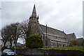
Church of St Jude
Grade II listed. http://www.britishlistedbuildings.co.uk/en-473190-church-of-st-jude-
Image: © N Chadwick
Taken: 28 Mar 2015
0.15 miles