IMAGES TAKEN NEAR TO
Woodside, PLYMOUTH, PL4 8QE
Introduction
This page details the photographs taken nearby to Woodside, PL4 8QE by members of the Geograph project.
The Geograph project started in 2005 with the aim of publishing, organising and preserving representative images for every square kilometre of Great Britain, Ireland and the Isle of Man.

There are currently over 7.5m images from over14,400 individuals and you can help contribute to the project by visiting https://www.geograph.org.uk
Image Map
Images are licensed for reuse under creativecommons.org/licenses/by-sa/2.0
Notes
- Clicking on the map will re-center to the selected point.
- The higher the marker number, the further away the image location is from the centre of the postcode.
Image Listing (70 Images Found)
Images are licensed for reuse under creativecommons.org/licenses/by-sa/2.0
Image
Details
Distance
1
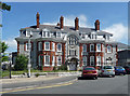
Freedom House, Greenbank Terrace, Plymouth
Built in 1909 as offices of the Board of Guardians of South Devon and East Cornwall Hospital. Grade II listed.
The hospital moved out in 1998 and this is now flats.
Image: © Stephen Richards
Taken: 17 Jun 2014
0.05 miles
2
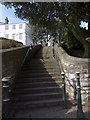
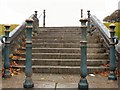
Steps to Freedom Fields
A flight of steps leads from Lipson Road up to the southwest corner of the park. The metal posts match those further up the road shown in Image The white house is on Woodside.
Image: © Derek Harper
Taken: 27 Mar 2010
0.06 miles
3
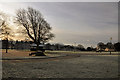
Freedom Fields Park - Plymouth
The park is situated at the top of a slope rising from the cliffs of the Sound to the south and drops away again to the north.
Image: © Mick Lobb
Taken: 31 Jan 2010
0.07 miles
4
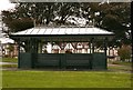
People Shelter Freedom Fields Plymouth
From here one can see the Sound. Plymouth Sound!
Image: © Mick Lobb
Taken: 4 Oct 2008
0.08 miles
5
Granite steps Freedom Fields Plymouth
Given a chance these steps could survive for as long as the Great Pyramids have - the bollards and rails too if spared by scrap metal thieves!
Image: © Mick Lobb
Taken: 4 Oct 2008
0.10 miles
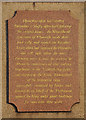
7
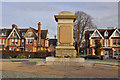
Civil War Memorial, Freedom Fields - Plymouth
The memorial bears the following inscription:
'Upon this spot on Sunday December 3rd 1643, after hard fighting for several hours, the Roundhead Garrison of Plymouth made their final rally and routed the Cavalier Army which had surprised the Outworks and well nigh taken the town. For many years it was the custom to celebrate the anniversary of this victory long known as the “Sabbath day fight” and recorded as the “Great Deliverance” of the protracted siege successfully sustained by Troops and Townsfolk on behalf of the Parliament against the King under great hardships for more than three years.'
Few who pass the memorial are aware of the reason for it being there and the part played by the citizens of the town during the momentous days of the English Civil War.
Image: © Mick Lobb
Taken: 31 Jan 2010
0.11 miles
8
Civil War Memorial, Freedom Fields - Plymouth
Image: © Mick Lobb
Taken: 31 Jan 2010
0.11 miles
9
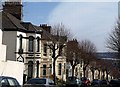
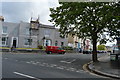
Beatrice Avenue, Plymouth
Like Image, with which it runs almost parallel, this street runs down the hill from Lipson Road. These houses have a little more decoration - and there are more trees.
Image: © Derek Harper
Taken: 27 Mar 2010
0.11 miles
10
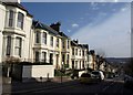
Greenbank Avenue, Plymouth
One of several streets of pleasant canted-bay-fronted terraces, which drop down with dramatic views to Cattewater and beyond.
Image: © Derek Harper
Taken: 27 Mar 2010
0.11 miles