IMAGES TAKEN NEAR TO
Mount Gould Road, PLYMOUTH, PL4 7PY
Introduction
This page details the photographs taken nearby to Mount Gould Road, PL4 7PY by members of the Geograph project.
The Geograph project started in 2005 with the aim of publishing, organising and preserving representative images for every square kilometre of Great Britain, Ireland and the Isle of Man.

There are currently over 7.5m images from over14,400 individuals and you can help contribute to the project by visiting https://www.geograph.org.uk
Image Map
Images are licensed for reuse under creativecommons.org/licenses/by-sa/2.0
Notes
- Clicking on the map will re-center to the selected point.
- The higher the marker number, the further away the image location is from the centre of the postcode.
Image Listing (25 Images Found)
Images are licensed for reuse under creativecommons.org/licenses/by-sa/2.0
Image
Details
Distance
2

St Simon's Lane Plymouth
Note the granite cobbled centre gutter of the lane. Most, if not all, of the 'backlanes' of the neighbourhood are completely cobbled but 'modern' concrete was used at some time in this lane's history.
Image: © Mick Lobb
Taken: 4 Oct 2008
0.06 miles
3
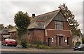
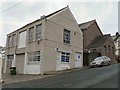
St Simon?s Mission Hall, Edith Avenue, Plymouth
Built in 1901 the church hall predates its mother church.
Image: © Mick Lobb
Taken: 4 Oct 2008
0.08 miles
4
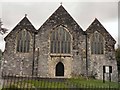
St Simon's Church, Salisbury Road Plymouth
The church was built of local limestone in the perpendicular style and until 1958 still had a temporary corrugated iron wall on the west side. Stone from the demolished Granby Barracks was recycled for the new wall.
The church was consecrated in 1907.
Image: © Mick Lobb
Taken: 4 Oct 2008
0.09 miles
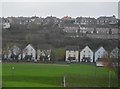
7
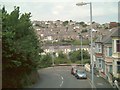
Lipson Hill
From Lipson Vale below (then part of the River Plym) to Freedom Fields at the top, this hill is reputed to be part of the battlefield in December 1642, when the Royalists failed to take the town. The Penzance/Paddington railway line runs parallel to the Vale with Mannamead in the background.
Image: © Jo Kenny
Taken: 10 Aug 2005
0.11 miles
8
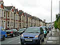
Salisbury Road, Plymouth
A long road of terraced houses on the slope of Mount Gould rising from the valley of the Plym.
Image: © Mick Lobb
Taken: 4 Oct 2008
0.12 miles
9
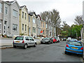
Neath Road, Plymouth
The roads, Neath, Salisbury and Edith, running parallel to the valley below end in cul-de-sacs at the point where they meet the grounds of Mount Gould Hospital. Note the camber of the road.
Image: © Mick Lobb
Taken: 4 Oct 2008
0.12 miles
10
Faringdon Road Plymouth
The steepness of the hill from Mount Gould to Tothill can be seen in this photograph of a Domestic Heating Suppliers premises.
Image: © Mick Lobb
Taken: 4 Oct 2008
0.13 miles