IMAGES TAKEN NEAR TO
Stour Close, PLYMOUTH, PL3 6RY
Introduction
This page details the photographs taken nearby to Stour Close, PL3 6RY by members of the Geograph project.
The Geograph project started in 2005 with the aim of publishing, organising and preserving representative images for every square kilometre of Great Britain, Ireland and the Isle of Man.

There are currently over 7.5m images from over14,400 individuals and you can help contribute to the project by visiting https://www.geograph.org.uk
Image Map (Loading...)


Getting Data...Please wait
Leaflet Map data © OpenStreetMap
Images are licensed for reuse under creativecommons.org/licenses/by-sa/2.0
Notes
- Clicking on the map will re-center to the selected point.
- The higher the marker number, the further away the image location is from the centre of the postcode.
Image Listing (13 Images Found)
Images are licensed for reuse under creativecommons.org/licenses/by-sa/2.0
Image
Details
Distance
1

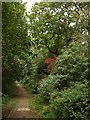
Path junction, Efford Marsh Nature Reserve
Paths diverge in the local nature reserve; left leads down to a meadow near the marsh, while right leads to a higher meadow below Efford Fort.
Image: © Derek Harper
Taken: 2 Oct 2009
0.05 miles
2

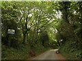
Military Road, Efford
The road runs through woodland from Efford Fort towards Little America.
Image: © Derek Harper
Taken: 2 Oct 2009
0.11 miles
3

Footpath, Efford Marsh Nature Reserve
Just for a few metres by this seat, the footpath in the local nature reserve runs across the corner of this square. The path eventually emerges into the Deerpark estate.
Image: © Derek Harper
Taken: 2 Oct 2009
0.13 miles
4
Footpath, Efford Marsh Nature Reserve
Further west along Image Close by on the right are ponds in Efford Marsh.
Image: © Derek Harper
Taken: 2 Oct 2009
0.15 miles
5
Road to Efford Fort
This is what you find when attempting to gain access to Efford Fort by the principal road leading to it. The notices say, unequivocally "no trespassing". "Efford Fort was one of the ring of Victorian Palmerston's Follies built to provide defence from risk of French invasion. The area was also heavily occupied by the American army during the preparations for D-Day". http://en.wikipedia.org/wiki/Efford . I can only echo the sentiments of Bob Bruce, one of a visiting party from the Plymouth & District Archaeological Society: "Most of us were surprised how extensive the Palmerston works were and how much had survived, though often concealed by vegetation. Some of us wondered whether Plymouth should be making more of this part of its military heritage." http://www.plymarchsoc.org.uk/laira%20battery%202.html
Image: © Derek Harper
Taken: 2 Oct 2009
0.19 miles
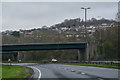
6
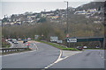
Plymouth : The Parkway A38
Looking towards the road junction with the B3413.
Image: © Lewis Clarke
Taken: 17 Mar 2020
0.19 miles
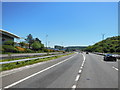
9
Plymouth : The Parkway A38
Heading along the main route through Plymouth.
Image: © Lewis Clarke
Taken: 17 Mar 2020
0.22 miles
10
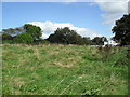
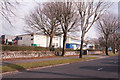
Efford
Looking across some open land towards High View Primary School.
Image: © Burgess Von Thunen
Taken: 19 Sep 2012
0.22 miles