IMAGES TAKEN NEAR TO
Pike Road, PLYMOUTH, PL3 6HJ
Introduction
This page details the photographs taken nearby to Pike Road, PL3 6HJ by members of the Geograph project.
The Geograph project started in 2005 with the aim of publishing, organising and preserving representative images for every square kilometre of Great Britain, Ireland and the Isle of Man.

There are currently over 7.5m images from over14,400 individuals and you can help contribute to the project by visiting https://www.geograph.org.uk
Image Map (Loading...)


Getting Data...Please wait
Leaflet Map data © OpenStreetMap
Images are licensed for reuse under creativecommons.org/licenses/by-sa/2.0
Notes
- Clicking on the map will re-center to the selected point.
- The higher the marker number, the further away the image location is from the centre of the postcode.
Image Listing (19 Images Found)
Images are licensed for reuse under creativecommons.org/licenses/by-sa/2.0
Image
Details
Distance
1
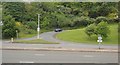
Near Colony Farm
An entrance to Efford Marsh Local Nature Reserve http://www.plymouth.gov.uk/effordmarsh . The footpath on the right curves round to enter the tunnel shown in Image and so reach Crabtree.
Image: © Derek Harper
Taken: 2 Oct 2009
0.11 miles
2

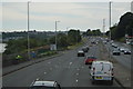
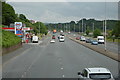
Filling up
Service station on Plymouth Road.
Image: © Robert Ashby
Taken: 5 Aug 2015
0.18 miles
3

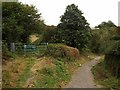
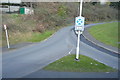
Military Road, Efford
The road runs through woodland from Efford Fort towards Little America.
Image: © Derek Harper
Taken: 2 Oct 2009
0.20 miles
4
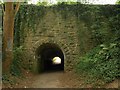
Efford Emplacement
"Efford Emplacement to the south of Efford Fort survives in the form of an earthwork rampart topped by three earthen traverses, each of which held two guns. It was an open earthwork battery sited across a small valley between Efford Fort and Laira Battery, facing due east and commanding the chicane approach to the sally port over which it is built. Built in 1869 to mount 4 64-pounders, it was later armed with six 8-inch rifled muzzle-loaders. Much of it is now covered over and infilled. " http://pastscape.english-heritage.org.uk/hob.aspx?a=0&hob_id=1396359&criteria=fort&search=all , with spelling amended. This is the tunnel shown in Image
Image: © Derek Harper
Taken: 2 Oct 2009
0.20 miles
7

Road to Efford Fort
This is what you find when attempting to gain access to Efford Fort by the principal road leading to it. The notices say, unequivocally "no trespassing". "Efford Fort was one of the ring of Victorian Palmerston's Follies built to provide defence from risk of French invasion. The area was also heavily occupied by the American army during the preparations for D-Day". http://en.wikipedia.org/wiki/Efford . I can only echo the sentiments of Bob Bruce, one of a visiting party from the Plymouth & District Archaeological Society: "Most of us were surprised how extensive the Palmerston works were and how much had survived, though often concealed by vegetation. Some of us wondered whether Plymouth should be making more of this part of its military heritage." http://www.plymarchsoc.org.uk/laira%20battery%202.html
Image: © Derek Harper
Taken: 2 Oct 2009
0.21 miles
8
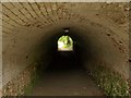
Tunnel, Crabtree
The 30-metre long tunnel carries a footpath beneath the Efford Emplacement, part of the Palmerston defences around Plymouth, and dating from around 1869.
Image: © Derek Harper
Taken: 2 Oct 2009
0.21 miles