IMAGES TAKEN NEAR TO
Kiel Place, PLYMOUTH, PL3 6DW
Introduction
This page details the photographs taken nearby to Kiel Place, PL3 6DW by members of the Geograph project.
The Geograph project started in 2005 with the aim of publishing, organising and preserving representative images for every square kilometre of Great Britain, Ireland and the Isle of Man.

There are currently over 7.5m images from over14,400 individuals and you can help contribute to the project by visiting https://www.geograph.org.uk
Image Map
Images are licensed for reuse under creativecommons.org/licenses/by-sa/2.0
Notes
- Clicking on the map will re-center to the selected point.
- The higher the marker number, the further away the image location is from the centre of the postcode.
Image Listing (71 Images Found)
Images are licensed for reuse under creativecommons.org/licenses/by-sa/2.0
Image
Details
Distance
5
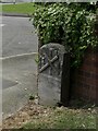
Old Boundary Marker on Old Laira Road, Plymouth
Municipal Boundary Marker facing east against the front garden wall of No.369 Old Laira Road, Plymouth, close to the junction with Manor Lane. Inscribed J.T. BOND / 1896 for John Thomas Bond, mayor.
Milestone Society National ID: DV_PCBS48pb
Image: © T Jenkinson
Taken: 31 May 2012
0.10 miles
7

Old Boundary Marker on Old Laira Road, Plymouth
Municipal Boundary Marker on the east side of the junction of the B3214 Old Laira Road and the A374 Embankment Road, Plymouth. Inscribed C.H. RADFORD / 1897 for Charles H Radford, mayor.
Milestone Society National ID: DV_PCBS49pb
Image: © T Jenkinson
Taken: 31 May 2012
0.10 miles
10
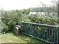
Old Boundary Marker on Embankment Road, Plymouth
Municipal Boundary Marker in front of a crash barrier where it meets metal railings on the southeast side of the A374 Embankment Road opposite the junction with Old Laira Road, Plymouth. Inscribed J.T. BOND / (1896) for John Thomas Bond, mayor.
Milestone Society National ID: DV_PCBS50pb
Image: © T Jenkinson
Taken: 31 May 2012
0.12 miles