IMAGES TAKEN NEAR TO
Richards Row, PLYMOUTH, PL3 5RH
Introduction
This page details the photographs taken nearby to Richards Row, PL3 5RH by members of the Geograph project.
The Geograph project started in 2005 with the aim of publishing, organising and preserving representative images for every square kilometre of Great Britain, Ireland and the Isle of Man.

There are currently over 7.5m images from over14,400 individuals and you can help contribute to the project by visiting https://www.geograph.org.uk
Image Map
Images are licensed for reuse under creativecommons.org/licenses/by-sa/2.0
Notes
- Clicking on the map will re-center to the selected point.
- The higher the marker number, the further away the image location is from the centre of the postcode.
Image Listing (46 Images Found)
Images are licensed for reuse under creativecommons.org/licenses/by-sa/2.0
Image
Details
Distance
1
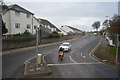
Old Boundary Marker on Torr Lane, Plymouth
Municipal Boundary Marker against the garden wall of Sungates, Torr Lane, Plymouth, near the junction with the B3250 Mannamead Road. Inscribed J.T. BOND / 1896 for John Thomas Bond, mayor.
Milestone Society National ID: DV_PCBS60pb
Image: © T Jenkinson
Taken: Unknown
0.04 miles
2
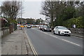
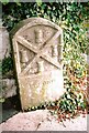
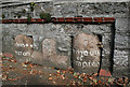
Old Parish Boundary Markers, Mannamead Road, Plymouth
Parish Boundary Marker by B3250 road, in parish of Plymouth (Plymouth District), Mannamead Road, by No. 154, 50m Northwest of Lockington Avenue, opposite Torr Lane, low down in wall above path by road; cemented in wall next to cross head.
On the left is Milestone Society National ID: DV_PLTV04Apb, inscribed Tything of / Weston / Peverell.
On the right is Milestone Society National ID: DV_PLTV04Bpb, inscribed Tything / of / Compton / Gifford.
Weston Peverell and Compton Gifford became separate parishes in 1899 and 1866 respectively.
See https://www.geograph.org.uk/photo/6099170 for details of cross.
surveyed
Image: © Alan Rosevear
Taken: 20 Oct 2010
0.05 miles

7
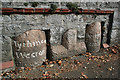
Old Wayside Cross, Mannamead Road, Plymouth
Compton Cross, old head and shaft by B3250 road, in parish of Plymouth (Plymouth District), Mannamead Road, 50m Northwest of Lockington Avenue, opposite Torr Lane, low down in wall above path by road; cemented in wall next to tithe boundary markers.
See http://www.geograph.org.uk/photo/6061028 for information on parish boundary markers.
Surveyed
Milestone Society National ID: DVPL_PLY04
Image: © Alan Rosevear
Taken: 20 Oct 2010
0.05 miles