IMAGES TAKEN NEAR TO
Tintagel Road, BOSCASTLE, PL35 0AR
Introduction
This page details the photographs taken nearby to Tintagel Road, PL35 0AR by members of the Geograph project.
The Geograph project started in 2005 with the aim of publishing, organising and preserving representative images for every square kilometre of Great Britain, Ireland and the Isle of Man.

There are currently over 7.5m images from over14,400 individuals and you can help contribute to the project by visiting https://www.geograph.org.uk
Image Map
Images are licensed for reuse under creativecommons.org/licenses/by-sa/2.0
Notes
- Clicking on the map will re-center to the selected point.
- The higher the marker number, the further away the image location is from the centre of the postcode.
Image Listing (70 Images Found)
Images are licensed for reuse under creativecommons.org/licenses/by-sa/2.0
Image
Details
Distance
1
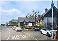
The Old Coach House, Boscastle
A guest house in the upper part of Boscastle village.
Image: © Des Blenkinsopp
Taken: 27 May 2021
0.01 miles
2
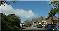
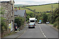
Doctors Hill, Boscastle
This is the B3263, becoming Barnpark Road as it bends left. The pale building just visible is the listed Barn Park https://historicengland.org.uk/listing/the-list/list-entry/1143495 .
Image: © Derek Harper
Taken: 19 May 2021
0.03 miles
3
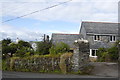
Slate-hung house and slate garden wall, Boscastle
On Potter's Lane.
Image: © Bill Harrison
Taken: 7 Jul 2012
0.05 miles
4
Paradise Road, Boscastle
The road runs past Paradise House
Image: © David Smith
Taken: 18 Apr 2018
0.10 miles
5
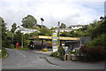
Boscastle filling station
Many village petrol stations have closed but this one lives on, accompanied by an excellent convenience store. Note the subtropical plants in the background...
Image: © Bill Harrison
Taken: 7 Jul 2012
0.10 miles
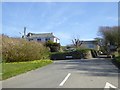
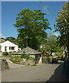
6
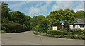
B road junction, Boscastle
The B3266 (foreground) ends here where it meets the B3263, the coast road.
Image: © Derek Harper
Taken: 19 May 2021
0.10 miles
9
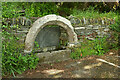
Drinking trough, Gunpool Lane, Boscastle
"A large mid nineteenth century granite drinking trough incorporating sixteenth-century material possibly from the demolished chapel of St James" https://map.cornwall.gov.uk/reports_conservation_areas/Boscastle.pdf .
Image: © Derek Harper
Taken: 19 May 2021
0.11 miles
10
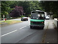
New Road, Boscastle
With a square shelter beside the road, which is the B3263.
Image: © Derek Harper
Taken: 19 May 2021
0.11 miles