IMAGES TAKEN NEAR TO
Thorn Park, PLYMOUTH, PL3 4TF
Introduction
This page details the photographs taken nearby to Thorn Park, PL3 4TF by members of the Geograph project.
The Geograph project started in 2005 with the aim of publishing, organising and preserving representative images for every square kilometre of Great Britain, Ireland and the Isle of Man.

There are currently over 7.5m images from over14,400 individuals and you can help contribute to the project by visiting https://www.geograph.org.uk
Image Map
Images are licensed for reuse under creativecommons.org/licenses/by-sa/2.0
Notes
- Clicking on the map will re-center to the selected point.
- The higher the marker number, the further away the image location is from the centre of the postcode.
Image Listing (61 Images Found)
Images are licensed for reuse under creativecommons.org/licenses/by-sa/2.0
Image
Details
Distance
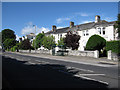
1
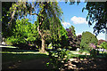
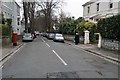
Thorn Park, Manamead - Plymouth
The well planted park is a clear indication of the affluent times when the area was developed.
Image: © Mick Lobb
Taken: 27 May 2010
0.04 miles
2
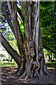
Multi-trunked tree in Mutley Park - Plymouth
Image: © Mick Lobb
Taken: 27 May 2010
0.05 miles
4
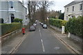
Thorn Park, Manamead - Plymouth
The road as well as the park itself and to the left is so called. The road follows a circular route around the small but well stocked park.
Image: © Mick Lobb
Taken: 27 May 2010
0.07 miles
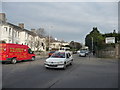
9
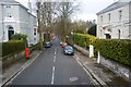
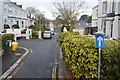
Mannamead Road
Bus stop and some of the large houses along the road.
Image: © Hugh Venables
Taken: 7 Jun 2009
0.08 miles
10
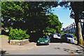
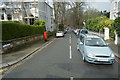
Plymouth : Mannamead Road
B3259 at the traffic lights on the junction with Seymour Road.
Image: © Lewis Clarke
Taken: 27 Jan 2010
0.09 miles