IMAGES TAKEN NEAR TO
Trerammet Crescent, TINTAGEL, PL34 0BN
Introduction
This page details the photographs taken nearby to Trerammet Crescent, PL34 0BN by members of the Geograph project.
The Geograph project started in 2005 with the aim of publishing, organising and preserving representative images for every square kilometre of Great Britain, Ireland and the Isle of Man.

There are currently over 7.5m images from over14,400 individuals and you can help contribute to the project by visiting https://www.geograph.org.uk
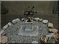
Image Map
Images are licensed for reuse under creativecommons.org/licenses/by-sa/2.0
Notes
- Clicking on the map will re-center to the selected point.
- The higher the marker number, the further away the image location is from the centre of the postcode.
Image Listing (111 Images Found)
Images are licensed for reuse under creativecommons.org/licenses/by-sa/2.0
Image
Details
Distance
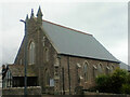
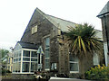
1
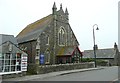
The Methodist Church, Tintagel
Most of the village of Tintagel was built in the 19C when tourism started.
Image: © Humphrey Bolton
Taken: 6 May 2009
0.02 miles
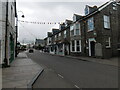
3
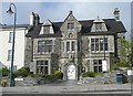
The Arthurian Centre, Tintagel
The emblem above the first-floor windows in the centre shows that this was a Masonic hall.
Image: © Humphrey Bolton
Taken: 6 May 2009
0.05 miles
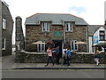
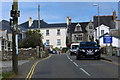
10
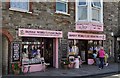
Tintagel : Granny Wobbly's Fudge Pantry
A shop named after Granny Wobbly which sells fresh crumbly fudge.
Image: © Lewis Clarke
Taken: 1 Jul 2011
0.06 miles