IMAGES TAKEN NEAR TO
Davidstow, CAMELFORD, PL32 9XP
Introduction
This page details the photographs taken nearby to PL32 9XP by members of the Geograph project.
The Geograph project started in 2005 with the aim of publishing, organising and preserving representative images for every square kilometre of Great Britain, Ireland and the Isle of Man.

There are currently over 7.5m images from over14,400 individuals and you can help contribute to the project by visiting https://www.geograph.org.uk
Image Map
Images are licensed for reuse under creativecommons.org/licenses/by-sa/2.0
Notes
- Clicking on the map will re-center to the selected point.
- The higher the marker number, the further away the image location is from the centre of the postcode.
Image Listing (9 Images Found)
Images are licensed for reuse under creativecommons.org/licenses/by-sa/2.0
Image
Details
Distance
1
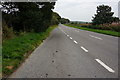
The A395
Heading West Southwest between Davidstow and the A39 towards Lauceston.
Image: © jeff collins
Taken: 17 Sep 2014
0.10 miles
2
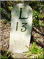
Old Milestone by the A395, near Trehane
Carved stone post by the A395, in parish of DAVIDSTOW (NORTH CORNWALL District), by Nandragon, near Trehane, South of Pendragon House, on lawn against hedge, on North side of road. Launceston pillar, erected by the Launceston turnpike trust in the 18th century.
Inscription reads:-
L
13
Grade II listed.
List Entry Number: 1394331 https://historicengland.org.uk/listing/the-list/list-entry/1394331
Milestone Society National ID: CW_LACF13.
Image: © Rosy Hanns
Taken: 20 Apr 2019
0.19 miles
3
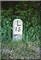
Old Milestone by the A395, near Trehane
Carved stone post by the A395, in parish of DAVIDSTOW (NORTH CORNWALL District), by Nandragon, near Trehane, South of Pendragon House, on lawn against hedge, on North side of road. Launceston pillar, erected by the Launceston turnpike trust in the 18th century.
Inscription reads:-
L
13
Grade II Listed. List Entry Number: 1394331
https://historicengland.org.uk/listing/the-list/list-entry/1394331
Milestone Society National ID: CW_LACF13.
Image: © Ian Thompson
Taken: 1 Jun 1996
0.20 miles
4
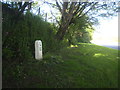
Milestone on the A395 at Trehane
Indicating 13 miles to Launceston.
Image: © Rod Allday
Taken: 2 Jun 2013
0.20 miles
5
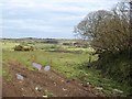
Field at Trewassa
A long rectangular field bounded by curving banks which drops towards a headwater of the Inny. Davidstow is partly obscured by the outstretched branches on the right.
Image: © Derek Harper
Taken: 18 Mar 2008
0.21 miles
6
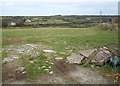
Field at Trewassa
The field slopes away from the lane entering Trewassa to a headwater of the Inny. Davidstow church, in SX1587, is on the right of the telegraph pole.
Image: © Derek Harper
Taken: 18 Mar 2008
0.22 miles
7
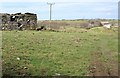
Outbuilding, Trewassa
A rural outbuilding on the fringe of the hamlet, seen from the same spot as Image Across the valley, in SX1487, is Trehane.
Image: © Derek Harper
Taken: 18 Mar 2008
0.24 miles
8
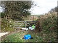
Tricky footpath, Trewassa
Footpath 509/5/1, which follows the lane down the north side of the hamlet, should continue ahead here towards Davidstow, but it doesn't look very promising, and there's certainly no waymarking.
Image: © Derek Harper
Taken: 18 Mar 2008
0.24 miles
9
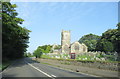
A395 Davidstow Passing St David's church
Image: © Roy Hughes
Taken: 28 Jun 2019
0.25 miles