IMAGES TAKEN NEAR TO
Lanteglos, CAMELFORD, PL32 9RG
Introduction
This page details the photographs taken nearby to PL32 9RG by members of the Geograph project.
The Geograph project started in 2005 with the aim of publishing, organising and preserving representative images for every square kilometre of Great Britain, Ireland and the Isle of Man.

There are currently over 7.5m images from over14,400 individuals and you can help contribute to the project by visiting https://www.geograph.org.uk
Image Map
Images are licensed for reuse under creativecommons.org/licenses/by-sa/2.0
Notes
- Clicking on the map will re-center to the selected point.
- The higher the marker number, the further away the image location is from the centre of the postcode.
Image Listing (22 Images Found)
Images are licensed for reuse under creativecommons.org/licenses/by-sa/2.0
Image
Details
Distance
1
Lanteglos-by-Camelford: St. Julitta's Church, north eastern aspect
Image: © Michael Garlick
Taken: 26 Sep 2018
0.08 miles
2
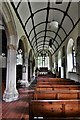
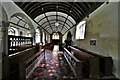
Lanteglos-by-Camelford: St. Julitta's Church, south aisle
Image: © Michael Garlick
Taken: 26 Sep 2018
0.09 miles
3
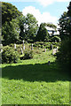
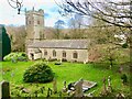
Camelford: Lanteglos churchyard
Not all the grass is cut; the churchyard is partly wild, encouraged by the Cornish Wildlife Trust
Image: © Martin Bodman
Taken: 22 Aug 2008
0.09 miles
4
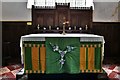
Lanteglos-by-Camelford, St. Julitta's Church: The altar
Image: © Michael Garlick
Taken: 26 Sep 2018
0.09 miles
5
Lanteglos-by-Camelford, St. Julitta's Church: The nave
Image: © Michael Garlick
Taken: 26 Sep 2018
0.09 miles
7
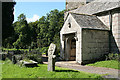
Camelford: Valley Truckle Cross
In St Julietta’s churchyard, Lanteglos. This wheel-headed wayside cross was discovered at Valley Truckle, in the parish, where its shaft had been used for binding tyres onto cart wheels at a blacksmith’s shop. It is 1.5m high and may date from the early middle ages [Source: Andrew Langdon, Stone Crosses in North Cornwall. Federation of Old Cornwall Societies, 1996, 43]
Image: © Martin Bodman
Taken: 22 Aug 2008
0.09 miles
8
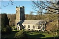
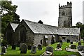
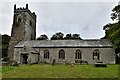
Church of St Julitta, Lanteglos
The grade I listed church is described at https://www.historicengland.org.uk/listing/the-list/list-entry/1142729 : "Norman origins with tower added in circa C14". The C19 restoration was by J P St Aubyn. This view is from the road to Helstone.
Image: © Derek Harper
Taken: 25 Jan 2017
0.09 miles
9
Lanteglos-by-Camelford: St. Julitta's Church southern aspect
Image: © Michael Garlick
Taken: 26 Sep 2018
0.09 miles
10
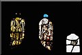
Lanteglos-by-Camelford, St. Julitta's Church: c15th stained glass
Image: © Michael Garlick
Taken: 26 Sep 2018
0.09 miles