IMAGES TAKEN NEAR TO
Farriers Green, CAMELFORD, PL32 9QY
Introduction
This page details the photographs taken nearby to Farriers Green, PL32 9QY by members of the Geograph project.
The Geograph project started in 2005 with the aim of publishing, organising and preserving representative images for every square kilometre of Great Britain, Ireland and the Isle of Man.

There are currently over 7.5m images from over14,400 individuals and you can help contribute to the project by visiting https://www.geograph.org.uk
Image Map
Images are licensed for reuse under creativecommons.org/licenses/by-sa/2.0
Notes
- Clicking on the map will re-center to the selected point.
- The higher the marker number, the further away the image location is from the centre of the postcode.
Image Listing (18 Images Found)
Images are licensed for reuse under creativecommons.org/licenses/by-sa/2.0
Image
Details
Distance
1
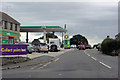
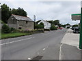
The B3266
Service station and minimarket on the outskirts of Camelford.
Image: © Robert Ashby
Taken: 21 Aug 2014
0.04 miles
3

BP filling station by A39 in Valley Truckle
Image: © David Smith
Taken: 18 Apr 2018
0.10 miles
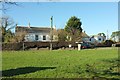
4
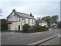
Cottage on the A39 at Valley Truckle
The easting grid line runs through the centre of the photo and the further cottages are in square Image
Image: © Rod Allday
Taken: 10 May 2013
0.11 miles
5
BP filling station in Valley Truckle
With an advert for a Londis store on site
Image: © David Smith
Taken: 7 Sep 2020
0.12 miles
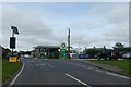
7
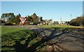
Junction at Valley Truckle
The B3266 meets the A39 here. Lots of signs and a BP station.
Image: © Derek Harper
Taken: 25 Jan 2017
0.17 miles
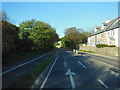
9
Houses at Valley Truckle
Looking left from where Image] was taken, across the A39. The pale grey granite block right of centre surmounted by a signpost is a listed "guidepost" https://www.historicengland.org.uk/listing/the-list/list-entry/1143561 : "Circa early C19. ... Granite monolith, triangular-on-plan. Directions to Bodmin, Camelford and Wadebridge inscribed on 3 faces in upper and lower case lettering with serifs". The side facing the camera bears "Bodmin".
Image: © Derek Harper
Taken: 25 Jan 2017
0.18 miles
10
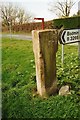
Old Guide Stone by the A39, Valley Truckle, Camelford
Stone post by the A39, in parish of Camelford (North Cornwall District), Valley Truckle Y-junction, A39/B3266, on grass. See also Image
Inscription on three faces reads:-
: Bodmin : : Camelford : : Wadebridge :
Grade II listed.
List Entry Number: 1143561 https://historicengland.org.uk/listing/the-list/list-entry/1143561
Surveyed
Milestone Society National ID: CW_XDSWB
Image: © Milestone Society
Taken: Unknown
0.18 miles