IMAGES TAKEN NEAR TO
Sportsmans, CAMELFORD, PL32 9QT
Introduction
This page details the photographs taken nearby to Sportsmans, PL32 9QT by members of the Geograph project.
The Geograph project started in 2005 with the aim of publishing, organising and preserving representative images for every square kilometre of Great Britain, Ireland and the Isle of Man.

There are currently over 7.5m images from over14,400 individuals and you can help contribute to the project by visiting https://www.geograph.org.uk
Image Map
Images are licensed for reuse under creativecommons.org/licenses/by-sa/2.0
Notes
- Clicking on the map will re-center to the selected point.
- The higher the marker number, the further away the image location is from the centre of the postcode.
Image Listing (14 Images Found)
Images are licensed for reuse under creativecommons.org/licenses/by-sa/2.0
Image
Details
Distance
1
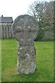
Old Wayside Cross
Trevia Cross, a wayside cross, with an old head & neck. Set at the junction of the B3266 and Clease Road. Camelford parish. Langdon NC No. 60. A Scheduled Monument https://historicengland.org.uk/listing/the-list/list-entry/1007967. See also http://www.geograph.org.uk/photo/1755022.
Milestone Society National ID: CWNC_CAM05
Image: © L Nott
Taken: 19 Oct 2019
0.03 miles
2
A Stone Cross
This small stone cross sits at a road junction on the outskirts of Camelford.
Image: © Tony Atkin
Taken: 7 Mar 2010
0.03 miles
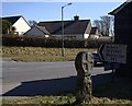
3
Clease Road, Camelford
This road links the B3266 with the A39
Image: © David Smith
Taken: 18 Apr 2018
0.06 miles
5
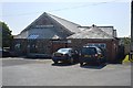
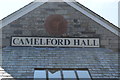
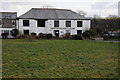
Camelford Hall - Clease Meadows
Former Territorial Force drill hall dating from 1911.
Now used as a village hall and modernised in 2000.
Image: © John M
Taken: 8 Sep 2014
0.20 miles
6
Camelford Hall - Clease Meadows
Former Territorial Force drill hall dating from 1911.
Now used as a village hall and modernised in 2000.
Image: © John M
Taken: 8 Sep 2014
0.20 miles
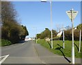
7
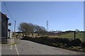
Country Road near Trevia Walls
Looking southeast past the high tension powerline which skirts the western edge of Camelford.
Image: © Tony Atkin
Taken: 7 Mar 2010
0.20 miles
8
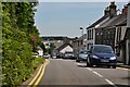
Camelford : A39 High Street
The High Street through Camelford on the A39.
Image: © Lewis Clarke
Taken: 4 Jul 2011
0.21 miles
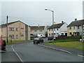
9
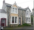
Houses, Camelford
Disguised semis, dated 1909, given away by the differing paint schemes. They have both kept the original barge-boards and window frames.
Image: © Humphrey Bolton
Taken: 6 May 2009
0.22 miles
10
North Cornwall Museum and Gallery
North Cornwall Museum and Gallery in Camelford.
Image: © Philip Halling
Taken: 19 Feb 2012
0.23 miles