IMAGES TAKEN NEAR TO
Advent, CAMELFORD, PL32 9QL
Introduction
This page details the photographs taken nearby to PL32 9QL by members of the Geograph project.
The Geograph project started in 2005 with the aim of publishing, organising and preserving representative images for every square kilometre of Great Britain, Ireland and the Isle of Man.

There are currently over 7.5m images from over14,400 individuals and you can help contribute to the project by visiting https://www.geograph.org.uk
Image Map
Images are licensed for reuse under creativecommons.org/licenses/by-sa/2.0
Notes
- Clicking on the map will re-center to the selected point.
- The higher the marker number, the further away the image location is from the centre of the postcode.
Image Listing (10 Images Found)
Images are licensed for reuse under creativecommons.org/licenses/by-sa/2.0
Image
Details
Distance
1
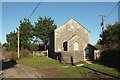
Bible Christian Chapel, Highertown
The chapel is also shown in Image; how those trees have grown in nine years! The lane is followed by NCN3 and the Moorland Walk.
Image: © Derek Harper
Taken: 25 Jan 2017
0.02 miles
2
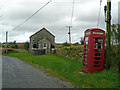
Chapel and telephone box
At Watergate Highertown; an ex-mining community south-east of Camelford.
Image: © Jonathan Billinger
Taken: 5 Feb 2008
0.03 miles
3
Lane at Highertown
A hamlet on the edge of Bodmin Moor. Both the Moorland Walk and NCN3 follow this stretch of lane.
Image: © Derek Harper
Taken: 25 Jan 2017
0.05 miles
4
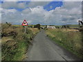
Lane leading N towards Wategate near Camelford
Image: © Colin Park
Taken: 11 Aug 2014
0.08 miles
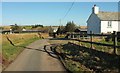
6
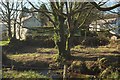
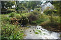
Houses at Watergate
Looking left from where Image] was taken, across Stannon Stream's western branch. On the right is Watergate Mill.
Image: © Derek Harper
Taken: 25 Jan 2017
0.13 miles
8
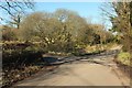
Junction, Watergate
A T junction on the NCN3, which proceeds ahead up the kain lane. The Moorland Walk here meets the Watermill Walk which uses the lane on the left, to Tresinney. Both trails then follow footpath 501 8/3 which uses a stile on the right of the steel gate you can see set back from the lane beneath a willow, just over a bridge across the Stannon Stream's western branch.
Image: © Derek Harper
Taken: 25 Jan 2017
0.15 miles
9
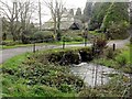
Ford at Watergate
This ford is found beside the road bridge in Watergate.
Image: © John Walton
Taken: 19 Sep 2015
0.15 miles
10
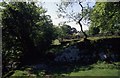
Watergate
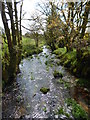
This path runs beside the stream that issues from Crowdy Reservoir. A solitary tree grows on top of an earth wall.
Image: © Chris Heaton
Taken: 25 May 1997
0.20 miles