IMAGES TAKEN NEAR TO
Valley View Caravan Site, BODMIN, PL31 2RA
Introduction
This page details the photographs taken nearby to Valley View Caravan Site, PL31 2RA by members of the Geograph project.
The Geograph project started in 2005 with the aim of publishing, organising and preserving representative images for every square kilometre of Great Britain, Ireland and the Isle of Man.

There are currently over 7.5m images from over14,400 individuals and you can help contribute to the project by visiting https://www.geograph.org.uk
Image Map
Images are licensed for reuse under creativecommons.org/licenses/by-sa/2.0
Notes
- Clicking on the map will re-center to the selected point.
- The higher the marker number, the further away the image location is from the centre of the postcode.
Image Listing (44 Images Found)
Images are licensed for reuse under creativecommons.org/licenses/by-sa/2.0
Image
Details
Distance
1
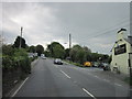
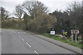
North Cornwall : The A389
The A389 heading through North Cornwall.
Image: © Lewis Clarke
Taken: 23 Feb 2014
0.01 miles
2
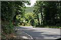
Dunmere : The A389
Looking along the A389 as it heads into Dunmere.
Image: © Lewis Clarke
Taken: 4 Jul 2011
0.03 miles
3
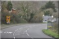
North Cornwall : The A389
At the road junction with Boundary Road and the A389.
Image: © Lewis Clarke
Taken: 23 Feb 2014
0.04 miles
4
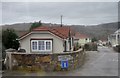
North Cornwall : Valley View Park
Valley View Park with some small houses near Bodmin.
Image: © Lewis Clarke
Taken: 23 Feb 2014
0.04 miles
5
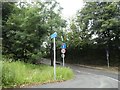
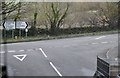
Junction of A389 with Boundary Road, Bodmin
Image: © David Smith
Taken: 7 Sep 2020
0.04 miles
6
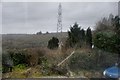
North Cornwall : Roadside Hedge
Looking towards a hedge and pylon in Cornwall.
Image: © Lewis Clarke
Taken: 23 Feb 2014
0.06 miles
7
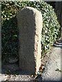
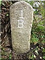
Old Milestone by the A389, south of Dunmere Bridge
Carved stone post by the A389, in parish of BODMIN (NORTH CORNWALL District), St Anne's Chapel, South of Dunmere bridge, opposite the South end of car park of Borough Arms PH, at end of hedge bank, by gate, on East side of road. Bodmin B Gravestone, erected by the Bodmin turnpike trust in the 18th century.
Inscription reads:-
1
B
Milestone Society National ID: CW_BMWB01.
Image: © Ian Thompson
Taken: 10 Sep 2014
0.06 miles
8
Old Milestone by the A389, west of Bodmin
Carved stone post by the A389, in parish of BODMIN (NORTH CORNWALL District), St Anne's Chapel, South of Dunmere bridge, opposite South end of car park of Borough Arms PH, at end of hedge bank, by gate, on East side of road. Bodmin 'B' Gravestone, erected by the Bodmin turnpike trust in the 18th century.
Inscription reads:-
1
B
Cornwall & Scilly HER.
HER Number: 178391 https://www.heritagegateway.org.uk/Gateway/Results_Single.aspx?uid=MCO54167&resourceID=1020
Milestone Society National ID: CW_BMWB01.
Image: © Rosy Hanns
Taken: 22 Mar 2019
0.06 miles
9
North Cornwall : Dunmere Road A389
The road heading from here towards Bodmin.
Image: © Lewis Clarke
Taken: 23 Feb 2014
0.07 miles