IMAGES TAKEN NEAR TO
Sandra Way, BODMIN, PL31 2PP
Introduction
This page details the photographs taken nearby to Sandra Way, PL31 2PP by members of the Geograph project.
The Geograph project started in 2005 with the aim of publishing, organising and preserving representative images for every square kilometre of Great Britain, Ireland and the Isle of Man.

There are currently over 7.5m images from over14,400 individuals and you can help contribute to the project by visiting https://www.geograph.org.uk
Image Map
Images are licensed for reuse under creativecommons.org/licenses/by-sa/2.0
Notes
- Clicking on the map will re-center to the selected point.
- The higher the marker number, the further away the image location is from the centre of the postcode.
Image Listing (38 Images Found)
Images are licensed for reuse under creativecommons.org/licenses/by-sa/2.0
Image
Details
Distance
1
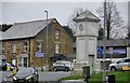
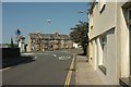
Bodmin : Dunmere Road
Dunmere Road and the clock tower in the town centre.
Image: © Lewis Clarke
Taken: 23 Feb 2014
0.09 miles
2
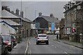
Bodmin : St Leonard's
Looking along the road known as St Leonard's in Bodmin.
Image: © Lewis Clarke
Taken: 23 Feb 2014
0.09 miles
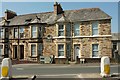
3
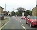
Salisbury Terrace, Bodmin
A view of the terrace of four seen across the Fiveways junction on the A389.
Image: © Derek Harper
Taken: 16 Aug 2016
0.10 miles
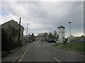
5
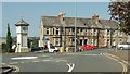
Fiveways Junction, Bodmin
St Mary's Road reaches the main junction at the west end of the town, with the three branches of the A389 at the clocktower. Across the junction is Salisbury Terrace.
Image: © Derek Harper
Taken: 16 Aug 2016
0.10 miles
6
Salisbury Terrace, Bodmin
The eastern end of the terrace shown in Image], from across St Leonards.
Image: © Derek Harper
Taken: 16 Aug 2016
0.10 miles
8
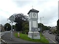
Clock tower in fork for Wadebridge, Bodmin
Image: © David Smith
Taken: 7 Sep 2020
0.10 miles
10
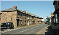
St Leonard's Terrace, Bodmin
Facing the road named St Leonard's, the A389. Neither has the inverted comma on the maps, but it seems to be used a fair amount elsewhere.
Image: © Derek Harper
Taken: 16 Aug 2016
0.12 miles