IMAGES TAKEN NEAR TO
Oakwood Park, BODMIN, PL31 2NZ
Introduction
This page details the photographs taken nearby to Oakwood Park, PL31 2NZ by members of the Geograph project.
The Geograph project started in 2005 with the aim of publishing, organising and preserving representative images for every square kilometre of Great Britain, Ireland and the Isle of Man.

There are currently over 7.5m images from over14,400 individuals and you can help contribute to the project by visiting https://www.geograph.org.uk
Image Map
Images are licensed for reuse under creativecommons.org/licenses/by-sa/2.0
Notes
- Clicking on the map will re-center to the selected point.
- The higher the marker number, the further away the image location is from the centre of the postcode.
Image Listing (13 Images Found)
Images are licensed for reuse under creativecommons.org/licenses/by-sa/2.0
Image
Details
Distance
1
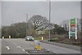
Bodmin : Launceston Road
The road heading out of Bodmin and past a retail park on the right.
Image: © Lewis Clarke
Taken: 23 Feb 2014
0.09 miles
2
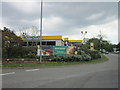
Morrisons petrol station on Priory Road, Bodmin
Image: © Ian S
Taken: 25 May 2013
0.17 miles

4

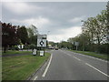
ASDA Bodmin
A view looking to the west towards the ASDA superstore from the pedestrian entrance on the A389 Launceston Road.
Image: © Phil Williams
Taken: 24 Mar 2007
0.18 miles

7

Bodmin : Motor Select Car Sales
An old looking garage now for used cars.
Image: © Lewis Clarke
Taken: 23 Feb 2014
0.20 miles

9
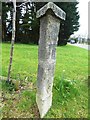
Old Guide Stone by the A389, Priory Road, Bodmin parish
Stone post by the A389, in parish of Bodmin (North Cornwall District), East of town, where Launceston and Liskeard roads divide, between roads on grass verge.
N.B. Stone has been moved further East from listed location due to roadworks.
For earlier photo see: Image
Inscription reads:-
: LANSON : : LISKEARD :
On shaft
: TO STATION :
Carved bench mark on South face of shaft.
Grade II listed.
List Entry Number: 1024996 https://historicengland.org.uk/listing/the-list/list-entry/1024996
Surveyed
Milestone Society National ID: CW_XBOD1
Image: © Rosy Hanns
Taken: 22 Mar 2019
0.21 miles
10

Old Guide Stone by the A389, Priory Road, Bodmin parish
Stone post by the A389, in parish of Bodmin (North Cornwall District), East of town, where Launceston and Liskeard roads divide, between roads on grass verge.
N.B. Stone has been moved further East from listed location due to roadworks. For earlier photo see: Image
Inscription reads:-
: LANSON : : LISKEARD :
On shaft
: TO STATION :
Grade II listed.
List Entry Number: 1024996 https://historicengland.org.uk/listing/the-list/list-entry/1024996
Surveyed
Milestone Society National ID: CW_XBOD1
Image: © Rosy Hanns
Taken: 22 Mar 2019
0.21 miles