IMAGES TAKEN NEAR TO
Hillside Park, BODMIN, PL31 2NE
Introduction
This page details the photographs taken nearby to Hillside Park, PL31 2NE by members of the Geograph project.
The Geograph project started in 2005 with the aim of publishing, organising and preserving representative images for every square kilometre of Great Britain, Ireland and the Isle of Man.

There are currently over 7.5m images from over14,400 individuals and you can help contribute to the project by visiting https://www.geograph.org.uk
Image Map
Images are licensed for reuse under creativecommons.org/licenses/by-sa/2.0
Notes
- Clicking on the map will re-center to the selected point.
- The higher the marker number, the further away the image location is from the centre of the postcode.
Image Listing (83 Images Found)
Images are licensed for reuse under creativecommons.org/licenses/by-sa/2.0
Image
Details
Distance
1
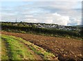
Bodmin and the Gilbert memorial
Looking South from farmland at the rear of dwelling on Copshorn Road. For information about the monument see Rod Allday's picture Image
Image: © Derek Voller
Taken: 23 Sep 2010
0.07 miles
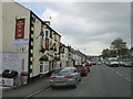
4
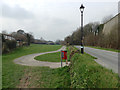
East end of Scarletts Well playing field, Bodmin
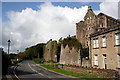
The path is a continuation of the cycleway from Padstow and Wadebridge. On the right is one of the massive walls to the former Bodmin Jail.
Image: © Robin Stott
Taken: 16 Mar 2015
0.09 miles
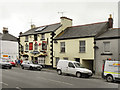
5
The state of religion in Bodmin, 4
The Bodmin Spiritualist Church and Healing Centre, formerly West End Snack Bar, at 57 Higher Bore Street and neighbour to Bodmin Children's Centre.
Image: © Robin Stott
Taken: 16 Mar 2015
0.10 miles
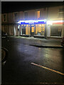
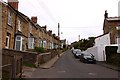
7
The Garland Ox Inn
Higher Bore Street, Bodmin
Image: © David Dixon
Taken: 26 Jul 2010
0.10 miles
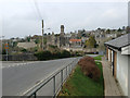
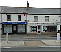
10
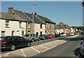
Higher Bore Street, Bodmin
The north side of the A389 approaching the junction with Dennison Road.
Image: © Derek Harper
Taken: 16 Aug 2016
0.11 miles