IMAGES TAKEN NEAR TO
Cross Lane, BODMIN, PL31 2EH
Introduction
This page details the photographs taken nearby to Cross Lane, PL31 2EH by members of the Geograph project.
The Geograph project started in 2005 with the aim of publishing, organising and preserving representative images for every square kilometre of Great Britain, Ireland and the Isle of Man.

There are currently over 7.5m images from over14,400 individuals and you can help contribute to the project by visiting https://www.geograph.org.uk
Image Map
Images are licensed for reuse under creativecommons.org/licenses/by-sa/2.0
Notes
- Clicking on the map will re-center to the selected point.
- The higher the marker number, the further away the image location is from the centre of the postcode.
Image Listing (55 Images Found)
Images are licensed for reuse under creativecommons.org/licenses/by-sa/2.0
Image
Details
Distance
1
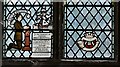
Bodmin, St. Petroc's Church: Dedicated stained glass window 2, the first dedication
Image: © Michael Garlick
Taken: 11 Jun 2016
0.09 miles
2
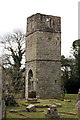
Berry Tower
Berry Tower was originally constructed between 1501 and 1511 and formed part of a large chapel which has since disappeared. The cemetery which now surrounds the tower was established in the 19th century.
Image: © Tony Atkin
Taken: 5 Apr 2008
0.11 miles
4
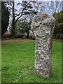
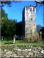
Old Wayside Cross
Berry Tower Cross, a moved Wayside Cross with an old head and shaft. Set beside the ruined church tower in Berry Hill cemetery in Bodmin parish. Grade II* Listed https://historicengland.org.uk/listing/the-list/list-entry/1195254. See also https://www.flickr.com/photos/bridgemarkertim/14206338102/.
Milestone Society National ID: CWNC_BOD03
Image: © L Nott
Taken: 19 Oct 2020
0.11 miles
6
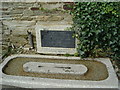
Memorial to a dog
This quirky memorial is found in the public carpark in the centre of Bodmin. Dedicated by the Prince Chula of Siam in 1948.
Image: © Terry Johnson
Taken: 3 Sep 2003
0.18 miles
7
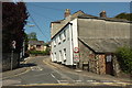
Castle Street, Bodmin
Mapped in one case as "Church Lane", and seen across the A389.
Image: © Derek Harper
Taken: 16 Aug 2016
0.20 miles
8
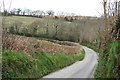
Helland Road
Walking out of Bodmin the townscape very quickly gives way to this rural scene.
Image: © Tony Atkin
Taken: 5 Apr 2008
0.20 miles
9
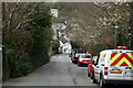
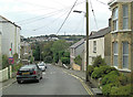
Berry Lane
Looking down the steep narrow road towards Bodmin town centre.
Image: © Tony Atkin
Taken: 5 Apr 2008
0.20 miles