IMAGES TAKEN NEAR TO
Love Lane, BODMIN, PL31 2BL
Introduction
This page details the photographs taken nearby to Love Lane, PL31 2BL by members of the Geograph project.
The Geograph project started in 2005 with the aim of publishing, organising and preserving representative images for every square kilometre of Great Britain, Ireland and the Isle of Man.

There are currently over 7.5m images from over14,400 individuals and you can help contribute to the project by visiting https://www.geograph.org.uk
Image Map
Images are licensed for reuse under creativecommons.org/licenses/by-sa/2.0
Notes
- Clicking on the map will re-center to the selected point.
- The higher the marker number, the further away the image location is from the centre of the postcode.
Image Listing (9 Images Found)
Images are licensed for reuse under creativecommons.org/licenses/by-sa/2.0
Image
Details
Distance

3
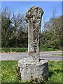
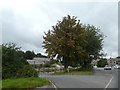
Old Wayside Cross at the junction of Castle Street, Old Callywith Road and Roselands Road, Bodmin
Castle Street Hill Cross, a wayside cross with an old head and shaft. Set on a grass triangle at the junction of Castle Street, Old Callywith Road and Roselands Road in Bodmin parish. Grade II Listed https://historicengland.org.uk/listing/the-list/list-entry/1195252. See also http://www.geograph.org.uk/photo/757140, https://www.geograph.org.uk/photo/4285026 and http://www.flickr.com/photos/ocifant/2879459265.
Milestone Society National ID: CWNC_BOD08
Image: © L Nott
Taken: 24 Apr 2021
0.22 miles
4
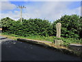
Ancient stone cross, Old Callywith Rd, Bodmin
Image: © Colin Park
Taken: 11 Aug 2014
0.22 miles
5

Bodmin, St. Petroc's Church: Dedicated stained glass window 2, the first dedication
Image: © Michael Garlick
Taken: 11 Jun 2016
0.22 miles
6
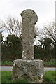
Ancient Stone Cross on Old Callywith Road
Sited in the grass triangle in the middle of a junction of minor roads, this cross is marked on both the 1:25,000 and 1:50,000 maps. It looks like it has lost part of its head at some point.
Image: © Tony Atkin
Taken: 5 Apr 2008
0.22 miles
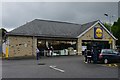
9
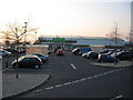
ASDA Bodmin
A view looking to the west towards the ASDA superstore from the pedestrian entrance on the A389 Launceston Road.
Image: © Phil Williams
Taken: 24 Mar 2007
0.24 miles