IMAGES TAKEN NEAR TO
Meadow Place, BODMIN, PL31 1JD
Introduction
This page details the photographs taken nearby to Meadow Place, PL31 1JD by members of the Geograph project.
The Geograph project started in 2005 with the aim of publishing, organising and preserving representative images for every square kilometre of Great Britain, Ireland and the Isle of Man.

There are currently over 7.5m images from over14,400 individuals and you can help contribute to the project by visiting https://www.geograph.org.uk
Image Map
Images are licensed for reuse under creativecommons.org/licenses/by-sa/2.0
Notes
- Clicking on the map will re-center to the selected point.
- The higher the marker number, the further away the image location is from the centre of the postcode.
Image Listing (138 Images Found)
Images are licensed for reuse under creativecommons.org/licenses/by-sa/2.0
Image
Details
Distance
1
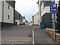
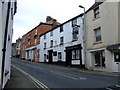
New housing, Northey Road / Fordh Northey off Crinnick's Hill, Bodmin
A sign indicates that the estate is a Home Zone, a residential space designed to be safely shared by people, children and vehicles. See https://en.wikipedia.org/wiki/Home_zone for an interesting history of the evolution of shared space in the UK since 1835, when the playing of football on the public highway was banned, and even children were sent to prison for kicking a ball about in the only available space.
Image: © Robin Stott
Taken: 16 Mar 2015
0.06 miles
2
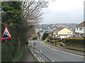
North and steeply down, Crinnick's Hill, Bodmin
20% on the sign derives from the old-style indication of gradient, '1 in 5' – just over 11° from the horizontal.
Image: © Robin Stott
Taken: 16 Mar 2015
0.09 miles
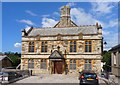
3
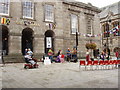
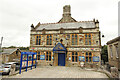
Shire Hall, Bodmin
This houses a Tourist Information Centre, a theatre, and the "Courtroom Experience".
"Built between 1837 and 1838 the Shire Hall is an architectural gem with its extraordinary interior cantilevered staircase and the imposing solid granite front facade. Used as the County Court until 1988 the building has now been carefully restored to its original glory by Bodmin Town Council using funds from the Lottery and from the European Fund", says its website www.bodminmoor.co.uk
Image: © David Hawgood
Taken: 1 Sep 2005
0.09 miles
5
George and Dragon, Bodmin
A break for St Austells ales on the long haul up to the station!
Image: © al partington
Taken: 28 Jul 2007
0.11 miles
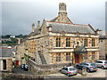
6
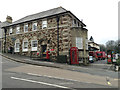
Capitol Cinema
Grade II listed former Town Hall by Ralling & Tonar of Exeter in 1891, now Capitol Cinema and Bodmin Museum.
Image: © Richard Croft
Taken: 5 Sep 2022
0.11 miles
7
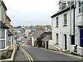
North and downhill on Crinnick's Hill, Bodmin
The steepness is no deterrent to nippy local traffic; it's a slow climb on foot.
Image: © Robin Stott
Taken: 16 Mar 2015
0.11 miles
8
Royal Mail Delivery Office, Crinnick's Hill, Bodmin
Image: © Robin Stott
Taken: 16 Mar 2015
0.12 miles
9
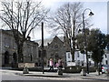
Bodmin Town Museum
Built as Public Rooms in 1891. Grade II listed http://www.imagesofengland.org.uk/Details/Default.aspx?id=368032&mode=adv.
Image: © Rod Allday
Taken: 22 Sep 2010
0.12 miles
10
Public Rooms, Bodmin
These public rooms, at the rear of the museum, were built in 1891. Currently out of use (2013), the town council is inviting local groups to submit business plans for its revival and future use.
Image: © mike smith
Taken: 7 Aug 2013
0.12 miles