IMAGES TAKEN NEAR TO
Beatrice Road, BODMIN, PL31 1EW
Introduction
This page details the photographs taken nearby to Beatrice Road, PL31 1EW by members of the Geograph project.
The Geograph project started in 2005 with the aim of publishing, organising and preserving representative images for every square kilometre of Great Britain, Ireland and the Isle of Man.

There are currently over 7.5m images from over14,400 individuals and you can help contribute to the project by visiting https://www.geograph.org.uk
Image Map (Loading...)


Getting Data...Please wait
Leaflet Map data © OpenStreetMap
Images are licensed for reuse under creativecommons.org/licenses/by-sa/2.0
Notes
- Clicking on the map will re-center to the selected point.
- The higher the marker number, the further away the image location is from the centre of the postcode.
Image Listing (10 Images Found)
Images are licensed for reuse under creativecommons.org/licenses/by-sa/2.0
Image
Details
Distance
1

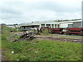
Train on Bodmin and Wenford Railway
The roofs of units in the adjacent industrial estate are visible above the locomotive.
Image: © David Martin
Taken: 10 Apr 2009
0.15 miles
2
Bodmin & Wenford Railway - sidings
Historic rolling stock in front of an engineering works in Bodmin.
Image: © Chris Allen
Taken: 21 Apr 2014
0.17 miles
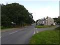
3
Respryn Road, Bodmin
Dropping to meet the B3268 past houses and industrial units.
Image: © Derek Harper
Taken: 16 Aug 2016
0.20 miles
4

A Warship locomotive back in Cornwall
Once a common sight in the 60s in the West Country only two of these 70 locomotives now survive in preservation. Based on the Severn Valley Railway 821 was back on the Bodmin line for one weekend only.
Image: © roger geach
Taken: 1 Apr 2001
0.21 miles
5
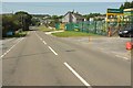
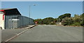
Carminow Road Industrial Estate
A road ending in tracks - actually very close to Castle Canyke Road, just behind the bushes.
Image: © Derek Harper
Taken: 16 Aug 2016
0.21 miles
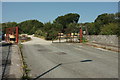
7
Carminow Road Industrial Estate
Ahead are the gates shown in Image
Image: © Derek Harper
Taken: 16 Aug 2016
0.23 miles
9
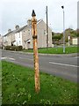
Old Direction Sign - Signpost by the B3268, Lostwithiel Road, Bodmin Parish
Finial - no arms; by the B3268, in parish of Bodmin (North Cornwall District), B3268 junction with Respryn Road, on long narrow grass triangle.
To be surveyed
Milestone Society National ID: CW_SX0765
Image: © Milestone Society
Taken: Unknown
0.25 miles
10
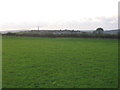
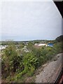
Castle Canyke
A view across the northwest quadrant of Castle Canyke, Bodmin. the bank and ditch earthwork can be seen along the hedge bordering the minor road. Beacon Hill with the Gilbert monument can be seen on the horizon.
Image: © Phil Williams
Taken: 8 Oct 2005
0.25 miles