IMAGES TAKEN NEAR TO
Withiel, BODMIN, PL30 5PA
Introduction
This page details the photographs taken nearby to PL30 5PA by members of the Geograph project.
The Geograph project started in 2005 with the aim of publishing, organising and preserving representative images for every square kilometre of Great Britain, Ireland and the Isle of Man.

There are currently over 7.5m images from over14,400 individuals and you can help contribute to the project by visiting https://www.geograph.org.uk
Image Map
Images are licensed for reuse under creativecommons.org/licenses/by-sa/2.0
Notes
- Clicking on the map will re-center to the selected point.
- The higher the marker number, the further away the image location is from the centre of the postcode.
Image Listing (9 Images Found)
Images are licensed for reuse under creativecommons.org/licenses/by-sa/2.0
Image
Details
Distance
1
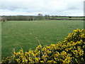
Pastures near Trevidgeowe Farm
Gorse in full bloom; the farm is in a dip beyond the trees at the end of the field.
Image: © Jonathan Billinger
Taken: 5 Mar 2008
0.09 miles
2
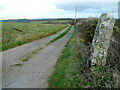
Track to Trevidgeowe Farm
The farm track seems to be recent as it is not on current mapping.
The menhir (standing stone) to the right is possibly a boundary marker.
Image: © Jonathan Billinger
Taken: 5 Mar 2008
0.09 miles
3
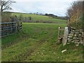
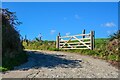
Gateway on the Saints Way
Looking through the gateway shown to the right of the barn in Image, on footpath 565/6/2.
Image: © Derek Harper
Taken: 17 Dec 2009
0.14 miles
4
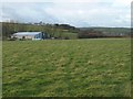
Saints Way near Trevidgeowe Farm
The Way follows footpath 565/6/2 across a grassy field between Retire and Withiel, whose church tower is to the right.
Image: © Derek Harper
Taken: 17 Dec 2009
0.15 miles
5
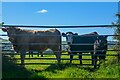
Withiel : Cattle
Cows looking from behind the fence.
Image: © Lewis Clarke
Taken: 2 Oct 2022
0.17 miles
6
Withiel : Road
A road to Trenance Barton.
Image: © Lewis Clarke
Taken: 2 Oct 2022
0.19 miles
8
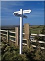
Old Direction Sign - Signpost near Trevidgeowe Farm, Withiel parish
Low pyramid finial - Cornwall CC Wood by the UC road, in parish of Withiel (North Cornwall District), at crossroads South of Trevidgeowe Farm, on verge at road edge, North side of junction.
Surveyed
Milestone Society National ID: CW_SW9964
Image: © Milestone Society
Taken: Unknown
0.24 miles
9
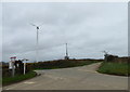
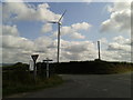
Road junction and wind turbine near Trevidgeowe Farm
Image: © Rod Allday
Taken: 19 Mar 2017
0.25 miles