IMAGES TAKEN NEAR TO
Waterloo, Blisland, BODMIN, PL30 4JX
Introduction
This page details the photographs taken nearby to PL30 4JX by members of the Geograph project.
The Geograph project started in 2005 with the aim of publishing, organising and preserving representative images for every square kilometre of Great Britain, Ireland and the Isle of Man.

There are currently over 7.5m images from over14,400 individuals and you can help contribute to the project by visiting https://www.geograph.org.uk
Image Map
Images are licensed for reuse under creativecommons.org/licenses/by-sa/2.0
Notes
- Clicking on the map will re-center to the selected point.
- The higher the marker number, the further away the image location is from the centre of the postcode.
Image Listing (11 Images Found)
Images are licensed for reuse under creativecommons.org/licenses/by-sa/2.0
Image
Details
Distance
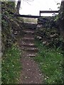
1
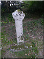
Stone Stile SX1072a
Towards the bottom end of the lane from Waterloo up to Cassacawn Road. The stile gives access to fields and to St Pratt’s Cross, SE of Blisland.
Seven stone steps on west side, slab top; one stone step and two bridging slabs on east side.
Public footpath from Waterloo to St Pratts’ Cross Footpath. 503/17/1 (Silver).
In conjunction with the stile at SX10385 73098 this is used as a short cut from Waterloo to Blisland village.
Image: © Anne Green
Taken: 28 Apr 2021
0.06 miles
2
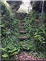
Stone Stile SX1072b
Beside the lane from Trewint to Waterloo (south east of Blisland village).
West Side: 6 stone steps topped with a granite slab.
East Side: 2 stone steps topped with the same granite slab.
The stile is at the north western end of FP No. 503/16/1 (Silver) which runs from the hamlet of Waterloo south east towards Stokely Farm and the moor.
Image: © Anne Green
Taken: 13 May 2021
0.09 miles
3
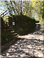
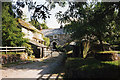
Lane to Waterloo
From where Image was taken, looking down the steep lane into the hamlet.
Image: © Derek Harper
Taken: 25 Jan 2017
0.10 miles
4
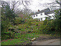
Cottage and wild garden
In the hamlet of Waterloo near Blisland.
Image: © Jonathan Billinger
Taken: 3 Apr 2008
0.12 miles
5
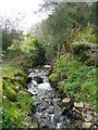
Fast-flowing stream
Near Trehudreth Mill, Waterloo.
Image: © Jonathan Billinger
Taken: 3 Apr 2008
0.12 miles
6
Blisland: Trehudreth Mill
Seen from the lane by the entrance. In 1893 J H Lang was listed as miller here in the local trade directory. The property is now a private residence
Image: © Martin Bodman
Taken: 13 Sep 1995
0.13 miles
7
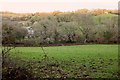
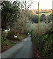
Valley, Waterloo
The lowering sun is only shining on the upper side of the valley. This view is from the steep hill between Trewint and Waterloo.
Image: © Derek Harper
Taken: 25 Jan 2017
0.14 miles
8
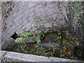
The Holy Well of Saint Protus
The water was diverted from its original wellspring in the mid 19th century.
Image: © Chris Gunns
Taken: 24 Sep 2013
0.24 miles
9
Stone Stile SX1073a
By St Pratt’s Cross, SE of Blisland village, on the lane leading up to the village.
Five steps up on the west side, stone slab at the top, two steps on the east side.
Public footpath 503/17/1 (Silver) from Waterloo to St Pratts’ Cross.
In conjunction with the stile at SX10658 72971 this is used as a short cut from Blisland to Waterloo where Blisland School is located.
In fact, this footpath isn’t used much by school children because there is another path, FP 503/18/1 Gold, which runs along the valley bottom below and parallel to FP No. 503/17/1.
Image: © Anne Green
Taken: 29 Apr 2021
0.24 miles