IMAGES TAKEN NEAR TO
Cassacawn, Blisland, BODMIN, PL30 4HL
Introduction
This page details the photographs taken nearby to PL30 4HL by members of the Geograph project.
The Geograph project started in 2005 with the aim of publishing, organising and preserving representative images for every square kilometre of Great Britain, Ireland and the Isle of Man.

There are currently over 7.5m images from over14,400 individuals and you can help contribute to the project by visiting https://www.geograph.org.uk
Image Map
Images are licensed for reuse under creativecommons.org/licenses/by-sa/2.0
Notes
- Clicking on the map will re-center to the selected point.
- The higher the marker number, the further away the image location is from the centre of the postcode.
Image Listing (3 Images Found)
Images are licensed for reuse under creativecommons.org/licenses/by-sa/2.0
Image
Details
Distance
1
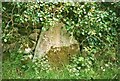
Old Milestone by Higher Penstroda, Blisland parish
Stone post by the UC road, in parish of Blisland (North Cornwall District), opposite Higher Penstroda farmhouse, free moorstone built into wall.
Inscription reads:-
BODMIN
5
Cornwall & Scilly HER.
HER Number: MCO64226 https://www.heritagegateway.org.uk/Gateway/Results_Single.aspx?uid=MCO64226&resourceID=1020
Surveyed
Milestone Society National ID: CW_XBLIS
Image: © Milestone Society
Taken: Unknown
0.01 miles
2
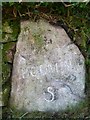
Old Milestone in Higher Penstroda
Milestone by the UC road, in parish of Blisland (North Cornwall District), opposite Higher Penstroda farmhouse, free moorstone built into wall.
Inscription reads:-
BODMIN
5
Cornwall & Scilly HER.
HER Number: MCO64226 https://www.heritagegateway.org.uk/Gateway/Results_Single.aspx?uid=MCO64226&resourceID=1020
Surveyed
Milestone Society National ID: CW_XBLIS
Image: © Rosy Hanns
Taken: 28 Mar 2019
0.01 miles
3
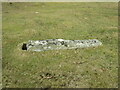
Old Boundary Marker on Trehudreth Downs, Blisland parish
Estate Boundary Marker on the open moorland of Trehudreth Downs 90 metres northeast of the moorland gate leading to the track to Wallhouse. Blisland parish.
One of 11 stones on the western edge of Trehudreth Downs that appear to mark out a strip of land of 12 acres that adjoin the enclosed farmland of Penstroda. These stones follow the remains of medieval ditches and banks that formerly enclosed this area. As this stone is recumbent only the inscription HP is visible. This indicates that part of this area was owned by Hayward.
Milestone Society National ID: CW_BLIS40em
Image: © P G Moore
Taken: Unknown
0.24 miles