IMAGES TAKEN NEAR TO
Greenwix Parc, BODMIN, PL30 3FA

Introduction

This page details the photographs taken nearby to Greenwix Parc, PL30 3FA by members of the Geograph project.

The Geograph project started in 2005 with the aim of publishing, organising and preserving representative images for every square kilometre of Great Britain, Ireland and the Isle of Man.

There are currently over 7.5m images from over14,400 individuals and you can help contribute to the project by visiting https://www.geograph.org.uk

Image Map


Images are licensed for reuse under creativecommons.org/licenses/by-sa/2.0
Notes
  • Clicking on the map will re-center to the selected point.
  • The higher the marker number, the further away the image location is from the centre of the postcode.

Image Listing (15 Images Found)

Images are licensed for reuse under creativecommons.org/licenses/by-sa/2.0
Image
Details
Distance
1
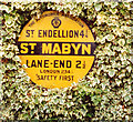
Old AA Sign on the St Mabyn Inn
Old AA Sign set on the wall of a side building of the St Mabyn Inn in St Mabyn, 4½ miles north of Bodmin. St Mabyn parish. This is the Circular, village name on black band, no Motor Union symbol or name type, dating from 1923, showing distances St Endillion 4¼ Lane-End 2½ London 234¼. There were five series of AA signs, mostly dating from 1923 and made by Francis & Co / Franco in Deptford, London. The village name and distance to London were displayed. See also https://www.flickr.com/photos/pix_of_brianc/2996468002. Milestone Society National ID: CW-STMAB
Image: © Milestone Society Taken: Unknown
0.08 miles
2
Old Wayside Cross
Lane End Cross, a wayside cross - moved, with an old head & shaft. Set in the churchyard. St Mabyn parish. Langdon NC No. 71. Grade II Listed https://historicengland.org.uk/listing/the-list/list-entry/1327972. See also http://www.flickr.com/photos/ocifant/2478105239. Milestone Society National ID: CWNC_SMA03
Image: © L Nott Taken: 13 Aug 2019
0.09 miles
3
St Mabyn War Memorial
On the edge of the village cemetery.
Image: © Rod Allday Taken: 24 Jul 2011
0.10 miles
4
Stone cross in St Mabyn churchyard
A Pre-Conquest granite wheelhead remounted on a circa late C19 shaft and base. The wheelhead has a raised Maltese cross on both faces. Grade II Listed.
Image: © Rod Allday Taken: 24 Jul 2011
0.10 miles
5
St Mabena church, St Mabyn
Image: © Dave Kelly Taken: 21 Aug 2006
0.10 miles
6
Ancient cross in St Mabena churchyard
Milestone Society National ID: CWNC_SMA03
Image: © Paul Barnett Taken: 22 Oct 2019
0.10 miles
7
St Mabena
Image: © Paul Barnett Taken: 22 Oct 2019
0.10 miles
8
The Church of St Mabena
Grade I Listed, St Mabyn's parish church is probably of Norman origin, with the font surviving. The existing fabric probably dates largely from the late C15. The tower is 75 feet high.
Image: © Rod Allday Taken: 24 Jul 2011
0.12 miles
9
St Mabyn: St Mabyn?s church and the St Mabyn Inn
Looking west. Mabyn or Mabon or Malbano was a female saint listed in 1234; she was thought to be one of twenty-four children of the Welsh king Brychan
Image: © Martin Bodman Taken: Unknown
0.12 miles
10
St Mabyn Stores and Post Office
Image: © Rod Allday Taken: 24 Jul 2011
0.13 miles