IMAGES TAKEN NEAR TO
PADSTOW, PL28 8RR
Introduction
This page details the photographs taken nearby to PL28 8RR by members of the Geograph project.
The Geograph project started in 2005 with the aim of publishing, organising and preserving representative images for every square kilometre of Great Britain, Ireland and the Isle of Man.

There are currently over 7.5m images from over14,400 individuals and you can help contribute to the project by visiting https://www.geograph.org.uk
Image Map (Loading...)


Getting Data...Please wait
Leaflet Map data © OpenStreetMap
Images are licensed for reuse under creativecommons.org/licenses/by-sa/2.0
Notes
- Clicking on the map will re-center to the selected point.
- The higher the marker number, the further away the image location is from the centre of the postcode.
Image Listing (18 Images Found)
Images are licensed for reuse under creativecommons.org/licenses/by-sa/2.0
Image
Details
Distance
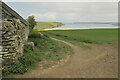
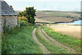
2
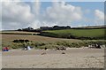
Holiday cottages at Tregirls Farm
Looking north on the lane from Padstow to Tregirls with Pentire in the distance (right of photo).
Image: © Andy F
Taken: 25 Aug 2009
0.03 miles
3
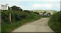
Tregirls Farm
The public access route ends here, and a footpath, 532 16/1, takes over past the farm down to Harbour Cove.
Image: © Derek Harper
Taken: 17 May 2021
0.03 miles
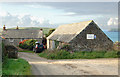
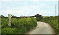
4
Tregirls Farm
Ahead, between the two barns, is the former farmhouse, now a pair of cottages. "Circa late C17. Stone rubble, slate hung with rag slates on front elevation ..."
Image: © Derek Harper
Taken: 17 May 2021
0.03 miles
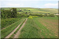
5
Path at Tregirls Farm
A similar scene to Image, with footpath 532 16/1 heading down towards Harbour Cove. The pilot and coastguard cottages Image] by the Camel estuary are visible left of centre.
Image: © Derek Harper
Taken: 17 May 2021
0.05 miles
6
Looking north on the road to Tregirls Farm
This lane leads from Prideaux Place to Tregirls Farm. The farmhouse is visible on the left of the photo and Lellizzick can be seen in the distance.
Image: © Andy F
Taken: 25 Aug 2009
0.07 miles
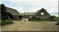
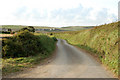
7
Approaching Tregirls
The lane from Prideaux Place approaches the farm at Tregirls, where it ends.
Image: © Derek Harper
Taken: 17 May 2021
0.07 miles
8
Path to Harbour Cove
Footpath 532 16/1 follows a track from Tregirls Farm.
Image: © Derek Harper
Taken: 17 May 2021
0.08 miles
9
Track and footpath north from Tregirls Farm to the beach
Image: © Andy F
Taken: 25 Aug 2009
0.10 miles
10
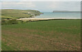
Towards the Camel estuary
Image: © Derek Harper
Taken: 17 May 2021
0.14 miles