IMAGES TAKEN NEAR TO
Boyd Avenue, PADSTOW, PL28 8HD
Introduction
This page details the photographs taken nearby to Boyd Avenue, PL28 8HD by members of the Geograph project.
The Geograph project started in 2005 with the aim of publishing, organising and preserving representative images for every square kilometre of Great Britain, Ireland and the Isle of Man.

There are currently over 7.5m images from over14,400 individuals and you can help contribute to the project by visiting https://www.geograph.org.uk
Image Map (Loading...)


Getting Data...Please wait
Leaflet Map data © OpenStreetMap
Images are licensed for reuse under creativecommons.org/licenses/by-sa/2.0
Notes
- Clicking on the map will re-center to the selected point.
- The higher the marker number, the further away the image location is from the centre of the postcode.
Image Listing (63 Images Found)
Images are licensed for reuse under creativecommons.org/licenses/by-sa/2.0
Image
Details
Distance
1
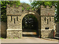
Entrance gateway to Prideaux Place
Grade II* listed: "Circa C18, pre 1758. Slate stone rubble ... Semi-circular dressed stone arch to entrance, with crenellations above, flanked by 2 square crenellated turrets with narrow slits and moulded plinths ..."
Image: © Derek Harper
Taken: 17 May 2021
0.17 miles
2
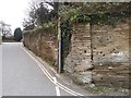
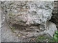
Boundary Wall
The boundary wall of Prideaux Place. On the lower part of the central column of the wall is the remains of a Ordnance Survey cut bench mark.
Image: © Mat Tuck
Taken: 1 Apr 2016
0.18 miles
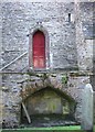
3
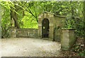
Garden seat, Prideaux Place
"Garden seat at south end of terrace. 1740 (datestone). By Edmund Prideaux. Vermiculated and dressed stone ashlar with side walls of rendered brick ... " https://www.heritagegateway.org.uk/Gateway/Results_Single.aspx?uid=1212203&resourceID=5 . The feature is grade II* listed.
Image: © Derek Harper
Taken: 17 May 2021
0.18 miles
4
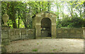
Garden seat, Prideaux Place
Another view of the grade II* listed structure shown in Image] https://historicengland.org.uk/listing/the-list/list-entry/1212203 .
Image: © Derek Harper
Taken: 17 May 2021
0.18 miles
5
Ordnance Survey cut bench mark
The remains of an Ordnance Survey cut bench mark.
Image: © Mat Tuck
Taken: 1 Apr 2016
0.19 miles
6

St Petroc's church, Padstow
The north side of the church, showing the double aisled layout typical of many Cornish churches.
Image: © Simon Huguet
Taken: 7 Aug 2008
0.19 miles
7
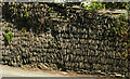
Slate wall, Church Street, Padstow
Looking left from Image]; most of the wall is composed of vertical slates, as in Image], although some repair has been needed here.
Image: © Derek Harper
Taken: 17 May 2021
0.19 miles
8
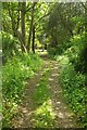
Track, Prideaux Place
Looking the other way from Image Ahead is a glimpse of the garden seat described at https://www.heritagegateway.org.uk/Gateway/Results_Single.aspx?uid=1212203&resourceID=5 at the end of the South Terrace https://www.heritagegateway.org.uk/Gateway/Results_Single.aspx?uid=1001249&resourceID=5 .
Image: © Derek Harper
Taken: 17 May 2021
0.19 miles
9
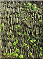
Wall, Padstow
Wall pennywort (Umbilicus rupestris) developing on a wall composed of vertical slates near the top of High Street.
Image: © Derek Harper
Taken: 6 Feb 2019
0.20 miles
10
St Petroc's church, Padstow
An unusual combination of features on the north side of the tower. The niche may have once held a tomb? The base of the tower dates from the C12th.
Image: © Simon Huguet
Taken: 7 Aug 2008
0.20 miles