IMAGES TAKEN NEAR TO
High Lanes, WADEBRIDGE, PL27 7SA
Introduction
This page details the photographs taken nearby to PL27 7SA by members of the Geograph project.
The Geograph project started in 2005 with the aim of publishing, organising and preserving representative images for every square kilometre of Great Britain, Ireland and the Isle of Man.

There are currently over 7.5m images from over14,400 individuals and you can help contribute to the project by visiting https://www.geograph.org.uk
Image Map (Loading...)


Getting Data...Please wait
Leaflet Map data © OpenStreetMap
Images are licensed for reuse under creativecommons.org/licenses/by-sa/2.0
Notes
- Clicking on the map will re-center to the selected point.
- The higher the marker number, the further away the image location is from the centre of the postcode.
Image Listing (7 Images Found)
Images are licensed for reuse under creativecommons.org/licenses/by-sa/2.0
Image
Details
Distance
1
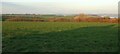
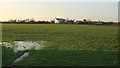
Towards Padstow
Looking NNE from where Image] was taken, across the Credis Creek valley and farmland. The obelisk shown in Image] is over on the right beside a glimpse of the Camel estuary.
Image: © Derek Harper
Taken: 20 Jan 2017
0.15 miles
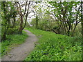
3
Boardwalk, Credis Creek
The Saints' Way follows footpath 532 8/2 across this side creek of Little Petherick Creek. Alas, this way where the way and I parted company. I think there must have been a tree down blocking the path beyond the creek, because I had to abandon the mapped route and try to find a way through the steep woodland above, which proved impossible. I ended up approaching the farmer at Credis, itself difficult to reach, who directed me up to the A389. A shame, because up until now the Saint's Way from Padstow had provided stunning scenery on a lovely afternoon.
Image: © Derek Harper
Taken: 20 Jan 2017
0.16 miles
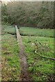
4
Credis Creek
A small creek off Little Petherick Creek, crossed near its head by a boardwalk carrying public footpath 532/8/2, the Saint's Way.
Image: © Hugh Craddock
Taken: 8 Mar 2008
0.18 miles
5
Towards St Kilda
The house is just into Image Footpath 541 6/1 crosses the field to meet the A389 a little left of the house, as shown in Image
Image: © Derek Harper
Taken: 20 Jan 2017
0.22 miles
6
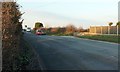
A389 north of Highlanes
Looking along the main road from the spot where Image was taken.
Image] looks in the opposite direction.
Image: © Derek Harper
Taken: 20 Jan 2017
0.25 miles
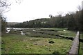
7
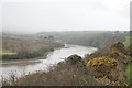
Little Petherick Creek
View from public footpath 532/8/2, the Saint's Way.
Image: © Hugh Craddock
Taken: 8 Mar 2008
0.25 miles