IMAGES TAKEN NEAR TO
Whiterock, WADEBRIDGE, PL27 7NN
Introduction
This page details the photographs taken nearby to PL27 7NN by members of the Geograph project.
The Geograph project started in 2005 with the aim of publishing, organising and preserving representative images for every square kilometre of Great Britain, Ireland and the Isle of Man.

There are currently over 7.5m images from over14,400 individuals and you can help contribute to the project by visiting https://www.geograph.org.uk
Image Map
Images are licensed for reuse under creativecommons.org/licenses/by-sa/2.0
Notes
- Clicking on the map will re-center to the selected point.
- The higher the marker number, the further away the image location is from the centre of the postcode.
Image Listing (171 Images Found)
Images are licensed for reuse under creativecommons.org/licenses/by-sa/2.0
Image
Details
Distance
1
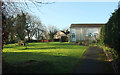
Lawn by St Breock residential home
In the Whiterock area of Wadebridge.
Image: © Derek Harper
Taken: 8 Feb 2020
0.02 miles
2
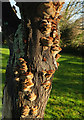
Bracket fungus, Whiterock
On a dead tree near St Breock car home.
Image: © Derek Harper
Taken: 8 Feb 2020
0.03 miles
3
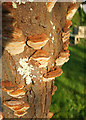
Bracket fungus, Whiterock
A closer look at Image
Image: © Derek Harper
Taken: 8 Feb 2020
0.03 miles
4

View from Whiterock Close, Wadebridge
A view from the cherry tree shown in Image
Image: © Derek Harper
Taken: 8 Feb 2020
0.04 miles
5

Green, Whiterock Close, Wadebridge
From its eastern corner; see also Image
Image: © Derek Harper
Taken: 8 Feb 2020
0.04 miles
6

Green, Whiterock Close, Wadebridge
A green at the east side of the close shown in Image], with terraced bungalows on three sides and a good view (see also Image]) on the fourth side (the east) over the Camel valley.
Image: © Derek Harper
Taken: 8 Feb 2020
0.05 miles
7
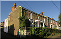
Whiterock Terrace, Wadebridge
All listed; the first pair are described at https://historicengland.org.uk/listing/the-list/list-entry/1142976 "Circa 1830s ... form part of an unaltered C19 terrace". The retaining wall is also listed https://historicengland.org.uk/listing/the-list/list-entry/1142977 , but I can't imagine that ivy is doing it any good. The Elizabethan postbox is PL27 15.
Image: © Derek Harper
Taken: 8 Feb 2020
0.05 miles
8
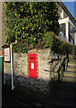
Postbox, Wadebridge
By Whiterock Terrace Image], this is Elizabeth II postbox PL27 15. The Wall, steps and wrought iron rail are listed https://historicengland.org.uk/listing/the-list/list-entry/1142977 , as is the terrace (https://historicengland.org.uk/listing/the-list/list-entry/1142976 describes the first two houses).
Image: © Derek Harper
Taken: 8 Feb 2020
0.05 miles
9
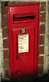
Postbox, Wadebridge
A close view of Elizabeth II postbox PL27 15, also shown in Image
Image: © Derek Harper
Taken: 8 Feb 2020
0.05 miles
10
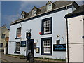
The Churchill Bars
A view looking to the northwest across Molesworth Street towards The Churchill Bars, also the Wadebridge Conservative Club.
Image: © Phil Williams
Taken: 26 Mar 2007
0.06 miles