IMAGES TAKEN NEAR TO
Glen Road, WADEBRIDGE, PL27 7LT
Introduction
This page details the photographs taken nearby to Glen Road, PL27 7LT by members of the Geograph project.
The Geograph project started in 2005 with the aim of publishing, organising and preserving representative images for every square kilometre of Great Britain, Ireland and the Isle of Man.

There are currently over 7.5m images from over14,400 individuals and you can help contribute to the project by visiting https://www.geograph.org.uk
Image Map (Loading...)


Getting Data...Please wait
Leaflet Map data © OpenStreetMap
Images are licensed for reuse under creativecommons.org/licenses/by-sa/2.0
Notes
- Clicking on the map will re-center to the selected point.
- The higher the marker number, the further away the image location is from the centre of the postcode.
Image Listing (230 Images Found)
Images are licensed for reuse under creativecommons.org/licenses/by-sa/2.0
Image
Details
Distance
2
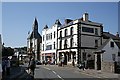
The Platt, Wadebridge
The Platt is the street which might be said to be at the heart of Wadebridge.
Image: © Tony Atkin
Taken: 15 Jul 2006
0.06 miles
3
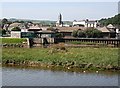
Wadebridge
Looking across the River Camel just upstream from the Old Bridge to the town centre.
Image: © Tony Atkin
Taken: 15 Jul 2006
0.06 miles
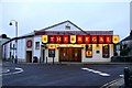
4
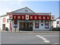
The Regal, Wadebridge
A view looking west towards the Regal cinema.
Image: © Phil Williams
Taken: 26 Mar 2007
0.06 miles
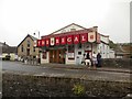
5
The Regal cinema in Wadebridge
The Regal, situated on The Platt in Wadebridge opened in January 1931.
Image: © Steve Daniels
Taken: 12 Jun 2011
0.07 miles
6
Wadebridge-Regal Cinema
The Methodist Church can also be seen in the background.
Image: © Ian Rob
Taken: 26 Jun 2015
0.07 miles
7
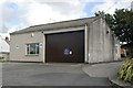
Wadebridge old fire station
Wadebridge old fire station, Hill Road, Wadebridge, Cornwall, now used as a depot for North Cornwall District Council.
Image: © Kevin Hale
Taken: 8 Jul 2007
0.07 miles
8
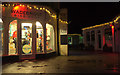
Polmorla Walk, Wadebridge, by night
Looking in the opposite direction to Image
Image: © Derek Harper
Taken: 5 Feb 2019
0.08 miles
9
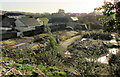
Vacant site, Wadebridge
On Polmorla Road and seen from the wall at the bend of Park Road shown in Image One plan is to develop this into a retail centre and 37 dwellings. "The site was previously used as a bakery and dairy and is now derelict" https://www.cornwalllive.com/news/cornwall-news/plans-new-shopping-centre-37-2405688 .
Image: © Derek Harper
Taken: 8 Feb 2020
0.09 miles
10
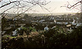
Wadebridge from Whiterock
A view across the southern part of the town.
Image: © Derek Harper
Taken: 8 Feb 2020
0.09 miles