IMAGES TAKEN NEAR TO
St. Breock, WADEBRIDGE, PL27 7HS
Introduction
This page details the photographs taken nearby to PL27 7HS by members of the Geograph project.
The Geograph project started in 2005 with the aim of publishing, organising and preserving representative images for every square kilometre of Great Britain, Ireland and the Isle of Man.

There are currently over 7.5m images from over14,400 individuals and you can help contribute to the project by visiting https://www.geograph.org.uk
Image Map
Images are licensed for reuse under creativecommons.org/licenses/by-sa/2.0
Notes
- Clicking on the map will re-center to the selected point.
- The higher the marker number, the further away the image location is from the centre of the postcode.
Image Listing (19 Images Found)
Images are licensed for reuse under creativecommons.org/licenses/by-sa/2.0
Image
Details
Distance
1
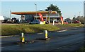
Petrol station, West Hill
From the same spot as Image] - and Image The Shell station is on the narrow stretch of land between the A39 and West Hill (foreground), the old main road which leads down into the centre of Wadebridge.
Image: © Derek Harper
Taken: 23 Jan 2017
0.07 miles
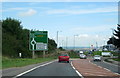
3
The A39
Ford dealership on the outskirts of Wadebridge.
Image: © Robert Ashby
Taken: 21 Aug 2014
0.08 miles
4
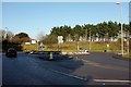
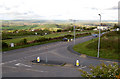
Roundabout by Royal Cornwall Showground
A fairly recent installation (formerly a T junction), this is where West Hill, the former main road west from Wadebridge, meets the A39 which bypasses the town to the north.
Image: © Derek Harper
Taken: 23 Jan 2017
0.08 miles
5
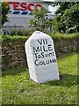
Old Milestone by the B3314, Gonvena Hill
Carved stone post by the B3314 (was A39), in parish of ST BREOCK (NORTH CORNWALL District), Gonvena Hill, Wadebridge, by Tesco supermarket, Trevanson, on wide verge, on South side of road. St Columb stone, erected by the Camelford, Wadebridge & St Columb turnpike trust in the 18th century.
Inscription reads:-
VII
MILE
To Saint
COLUMB
Carved benchmark on top.
Grade II Listed. List Entry Number:1143059
https://historicengland.org.uk/listing/the-list/list-entry/1143059
Milestone Society National ID: CW_SCWB07.
Image: © Ian Thompson
Taken: 10 Dec 2017
0.10 miles
6
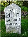
Old Milestone by the B3314, Gonvena Hill
Carved stone post by the B3314 (was A39), in parish of ST BREOCK (NORTH CORNWALL District), Gonvena Hill, Wadebridge, by Tesco supermarket, Trevanson, on wide verge, on South side of road. St Columb stone, erected by the Camelford, Wadebridge & St Columb turnpike trust in the 18th century.
Inscription reads:-
VII
MILE
To Saint
COLUMB
Carved benchmark on top.
Grade II listed.
List Entry Number: 1143059 https://historicengland.org.uk/listing/the-list/list-entry/1143059
Milestone Society National ID: CW_SCWB07.
Image: © Rosy Hanns
Taken: 11 May 2019
0.10 miles
7
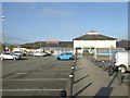
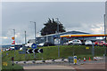
Tesco store and car-park, Wadebridge
Early morning so the car-park is almost empty
Image: © David Smith
Taken: 19 Apr 2018
0.13 miles
8
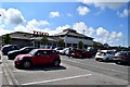
Tesco, Wadebridge
Supermarket near the County Showground
Image: © John Myers
Taken: 26 May 2015
0.13 miles
9
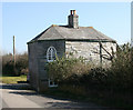
Former Wadebridge Tollhouse, Whitecross Road, St Breock
Tollhouse by the unclassified road (was A39), in the parish of St Breock (North Cornwall District), Tollgate House (the Roundhouse), Whitecross Road, PL27 7HT.
Grade II listed.
List Entry Number: 1310957 https://historicengland.org.uk/listing/the-list/list-entry/1310957
Surveyed
Milestone Society National ID: CW.STB
Image: © Alan Rosevear
Taken: 19 Dec 2007
0.15 miles
10
Entrance to Tesco, Wadebridge
Looking from the Tesco carpark to the junction with the old A39 (now bypassed). For a view from the car park, see [http://www.geograph.org.uk/photo/1285076] .
Image: © Andy F
Taken: 30 Apr 2009
0.16 miles