IMAGES TAKEN NEAR TO
Elmsleigh Road, WADEBRIDGE, PL27 7HA
Introduction
This page details the photographs taken nearby to Elmsleigh Road, PL27 7HA by members of the Geograph project.
The Geograph project started in 2005 with the aim of publishing, organising and preserving representative images for every square kilometre of Great Britain, Ireland and the Isle of Man.

There are currently over 7.5m images from over14,400 individuals and you can help contribute to the project by visiting https://www.geograph.org.uk
Image Map (Loading...)


Getting Data...Please wait
Leaflet Map data © OpenStreetMap
Images are licensed for reuse under creativecommons.org/licenses/by-sa/2.0
Notes
- Clicking on the map will re-center to the selected point.
- The higher the marker number, the further away the image location is from the centre of the postcode.
Image Listing (54 Images Found)
Images are licensed for reuse under creativecommons.org/licenses/by-sa/2.0
Image
Details
Distance
1
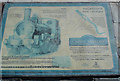
Sign near the line
A bit of info on the old line.
Bodmin to Wadebridge Opened 1834
Wadebridge to Padstow Opened 1899
Line closed 1967
Image: © Jimmy Reeves
Taken: 10 Aug 2005
0.06 miles
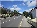
2
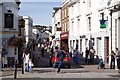
Molesworth Street, Wadebridge
Incredibly, this was North Cornwall's main trunk road, the A39, as recently as 1993. Despite the presence of the car, it is now a pedestrian zone.
Image: © Ron Strutt
Taken: 12 Sep 2003
0.06 miles
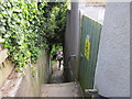
6
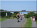
Wadebridge to Padstow "Cycle Track"
White Van Man seems to be oblivious to the fact that this former railway was converted into the Camel Trail for cyclist's and walkers.The River Camel is to the right of the picture.
Image: © Jimmy Reeves
Taken: 11 Jul 2005
0.14 miles
8
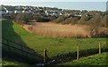
Reeds by the Camel Trail, Wadebridge
These seem to be filling a pond close to a flood relief barrier (left). Behind is housing to the northwest of the town centre.
Image: © Derek Harper
Taken: 20 Jan 2017
0.14 miles
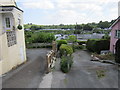
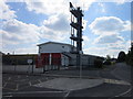
9
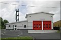
Wadebridge Fire Station
Wadebridge Fire Station, Piggy Lane, Wadebridge, Cornwall.
Image: © Kevin Hale
Taken: 21 May 2006
0.15 miles
10
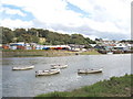
Boats on the Camel at Wadebridge
View from the Camel Trail, just below the bridge, with a boatyard on the opposite bank.
Image: © David Hawgood
Taken: 17 Aug 2006
0.15 miles