IMAGES TAKEN NEAR TO
Fernleigh Road, WADEBRIDGE, PL27 7FD
Introduction
This page details the photographs taken nearby to Fernleigh Road, PL27 7FD by members of the Geograph project.
The Geograph project started in 2005 with the aim of publishing, organising and preserving representative images for every square kilometre of Great Britain, Ireland and the Isle of Man.

There are currently over 7.5m images from over14,400 individuals and you can help contribute to the project by visiting https://www.geograph.org.uk
Image Map (Loading...)


Getting Data...Please wait
Leaflet Map data © OpenStreetMap
Images are licensed for reuse under creativecommons.org/licenses/by-sa/2.0
Notes
- Clicking on the map will re-center to the selected point.
- The higher the marker number, the further away the image location is from the centre of the postcode.
Image Listing (189 Images Found)
Images are licensed for reuse under creativecommons.org/licenses/by-sa/2.0
Image
Details
Distance
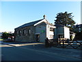
1
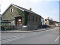
The Old Goods Shed
A view looking to the northwest towards the Old Goods Shed, now in use as sports hall and healing therapies centre. The building in the background is the old station building, now the John Betjeman Centre.
Image: © Phil Williams
Taken: 26 Mar 2007
0.03 miles
2
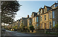
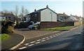
Fernleigh Road, Wadebridge
Terraced houses either side of the junction with Hill Road.
Image: © Derek Harper
Taken: 8 Feb 2020
0.05 miles
3
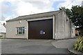
Wadebridge old fire station
Wadebridge old fire station, Hill Road, Wadebridge, Cornwall, now used as a depot for North Cornwall District Council.
Image: © Kevin Hale
Taken: 8 Jul 2007
0.05 miles
4
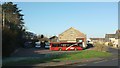
Wadebridge bus station
On Southern Way (right), which carries the Camel Trail. The bus station stands across part of the site of the former Wadebridge station, "one of the oldest railway stations in the country" http://www.disused-stations.org.uk/w/wadebridge/ and the former goods shed, the gabled building behind the red bus, is now the Betty Fisher Centre, a Rethink Mental Illness centre.
Image: © Derek Harper
Taken: 23 Jan 2017
0.06 miles
5
Guineaport Parc, Wadebridge
A small cul-de-sac off Guineaport Road (right, and which carries the Camel Trail). But see Image], showing the path that links the two sections of Guineaport Parc.
Image: © Derek Harper
Taken: 23 Jan 2017
0.06 miles
6
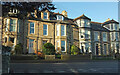
Fernleigh Road, Wadebridge
The left end of this terrace is shown in Image View from Guineaport Road.
Image: © Derek Harper
Taken: 8 Feb 2020
0.07 miles
7
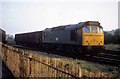
Wadebridge freight
When Wadebridge had a railway , at 0545 hrs locomotive 25155 shunts the freight yard not long before freight services were withdrawn.On the left can be seen the goods shed which still stands today. A road and houses are now to be found where the locomotive stands. By 0555 the train had gone , most people would still be in bed and would never know that the railway was still in operation. 31 years on who would even know the railway was here and of course employed quite a large number of people with a large station and locomotive shed.
Image: © roger geach
Taken: 4 Jul 1977
0.07 miles
8

Guineaport Parc, Wadebridge
Guineaport Parc forms a crescent off Guineaport Road, but is split in two; the two parts are only accessible using this footpath.
Image: © Derek Harper
Taken: 23 Jan 2017
0.07 miles
9
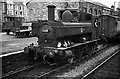
1368 shunting at Wadebridge Station ? 1964
One of a class of just 6 locomotives, built in 1934 ostensibly for docks work. It was one of three that ended up at Wadebridge to work the Wenford Bridge china clay branch. Withdrawn later that year.
This view https://www.geograph.org.uk/photo/380908 is taken from almost exactly the same spot. The goods shed survives, but motor traffic now runs where the trains used to.
Image: © Alan Murray-Rust
Taken: Unknown
0.07 miles
10
Former Railway Goods Shed, Wadebridge
Image: © Roger Cornfoot
Taken: 12 Aug 2016
0.08 miles