IMAGES TAKEN NEAR TO
Wentworth Close, WADEBRIDGE, PL27 6TH
Introduction
This page details the photographs taken nearby to Wentworth Close, PL27 6TH by members of the Geograph project.
The Geograph project started in 2005 with the aim of publishing, organising and preserving representative images for every square kilometre of Great Britain, Ireland and the Isle of Man.

There are currently over 7.5m images from over14,400 individuals and you can help contribute to the project by visiting https://www.geograph.org.uk
Image Map
Images are licensed for reuse under creativecommons.org/licenses/by-sa/2.0
Notes
- Clicking on the map will re-center to the selected point.
- The higher the marker number, the further away the image location is from the centre of the postcode.
Image Listing (36 Images Found)
Images are licensed for reuse under creativecommons.org/licenses/by-sa/2.0
Image
Details
Distance
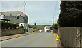
1
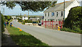
White Heron
The hotel, on the right, is on the unnamed road to Polzeath.
Image: © Derek Harper
Taken: 18 May 2021
0.05 miles
2
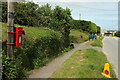
Road to Polzeath
Taken just north of Image, with Elizabeth II postbox PL27 69 attached to a telegraph pole on the left.
Image: © Derek Harper
Taken: 18 May 2021
0.06 miles
3
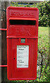
Postbox, Polzeath
A closer look at the Elizabeth II postbox PL27 69 shown in Image
Image: © Derek Harper
Taken: 18 May 2021
0.06 miles
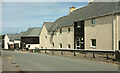
4
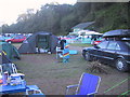
Camping in Polzeath, Summer 2004.
Valley Caravan Park, Old Polzeath, North Cornwall,
Image: © David Cumberland
Taken: 31 Aug 2004
0.09 miles
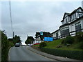
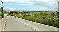
5
Road into Polzeath
Beginning a steep descent past the Oystercatcher pub, whose sign can be seen on the left.
Image: © Derek Harper
Taken: 18 May 2021
0.09 miles
6
The Oyster Catcher Polzeath Hill
Nearing the top of the hill is The Oyster Catcher public house. Fine views down the hill and out to sea over Polzeath
Image: © William Bartlett
Taken: 26 Aug 2006
0.10 miles
7
Francis Road, Polzeath
A turning off the road shown in Image
Image: © Derek Harper
Taken: 18 May 2021
0.10 miles
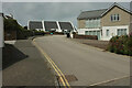
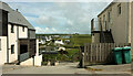
8
Pinewood Court, Polzeath
Flats on the steep hill down to the beach.
Image: © Derek Harper
Taken: 18 May 2021
0.11 miles
9
View, Polzeath
A view between buildings on the stretch of road shown in Image Houses on Dunders Hill are across the Polzeath Brook valley.
Image: © Derek Harper
Taken: 18 May 2021
0.11 miles
10
Road to Polzeath
Just a little further along the road shown in Image], with the sign for Polzeath visible in both.
Image: © Derek Harper
Taken: 18 May 2021
0.13 miles