IMAGES TAKEN NEAR TO
St. Minver, WADEBRIDGE, PL27 6QY
Introduction
This page details the photographs taken nearby to PL27 6QY by members of the Geograph project.
The Geograph project started in 2005 with the aim of publishing, organising and preserving representative images for every square kilometre of Great Britain, Ireland and the Isle of Man.

There are currently over 7.5m images from over14,400 individuals and you can help contribute to the project by visiting https://www.geograph.org.uk
Image Map (Loading...)


Getting Data...Please wait
Leaflet Map data © OpenStreetMap
Images are licensed for reuse under creativecommons.org/licenses/by-sa/2.0
Notes
- Clicking on the map will re-center to the selected point.
- The higher the marker number, the further away the image location is from the centre of the postcode.
Image Listing (30 Images Found)
Images are licensed for reuse under creativecommons.org/licenses/by-sa/2.0
Image
Details
Distance
1
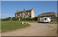
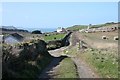
Cottages, Pentireglaze
Shown on the left of Image, these farm cottages are owned by the National Trust. One is holiday accommodation, one is let.
Image: © Derek Harper
Taken: 27 Apr 2011
0.00 miles
2
NT cottages on road to Pentire Farm
Looking north to the National Trust cottages on the lane to Pentire Farm. On the left is Overhaven and in the centre are West Cottage and East Cottage.
Image: © Andy F
Taken: 2 May 2009
0.01 miles
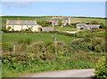
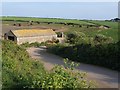
3
Pentireglaze
A tiny hamlet in National Trust ownership, with three of the properties offered as self-catering holiday accommodation. Between the cottages on the left and the former farmhouse on the right (http://www.britishlistedbuildings.co.uk/en-351584-overhaven-st-minver-highlands ) are the farm buildings shown in Image, now used by Pentire Farm (also NT-owned). Taken on the road from the lead mines car park.
Image: © Derek Harper
Taken: 26 Apr 2011
0.02 miles
4
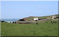
Pentireglaze
The hamlet of Pentireglaze. Pentire Point rises above the Old Farmhouse (yellow washed walls). The valley drops down to Pentireglaze Haven, out of sight. Gulland Rock is offshore.
Image: © Hugh Craddock
Taken: 7 Mar 2008
0.03 miles
5
Pentireglaze from the Old Cottage
The Old Farmhouse (yellow-washed walls) stands out in Pentireglaze, with two cottages (Pentireglaze East and West) slightly higher and to the right. Taken from public footpath 546/31/1, which links with the coast path.
Image: © Hugh Craddock
Taken: 7 Mar 2008
0.03 miles
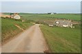
7
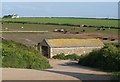
Barns, Pentireglaze
The barns can be seen from the opposite direction left of centre in Image The modern house on the ridge is Bellapaise.
Image: © Derek Harper
Taken: 26 Apr 2011
0.06 miles
8
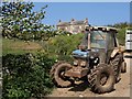
Tractor, Pentireglaze
A Ford tractor taking its lunch break beside some apple blossom. In the background are the cottages shown in Image
Image: © Derek Harper
Taken: 27 Apr 2011
0.06 miles
9
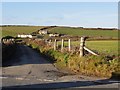
Lane at Pentireglaze
Similar to Image, with the lane to Polzeath crossing the valley that leads down to the sea at Pentireglaze Haven. Alexanders in the foreground.
Image: © Derek Harper
Taken: 26 Apr 2011
0.09 miles
10
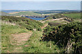
St Minver Highlands: on the South West Coast Path
Looking across Port Quin Bay to Doyden House, the white building in the distance
Image: © Martin Bodman
Taken: 17 Sep 2009
0.10 miles