IMAGES TAKEN NEAR TO
Band House Lane, ST. AUSTELL, PL26 8TE
Introduction
This page details the photographs taken nearby to Band House Lane, PL26 8TE by members of the Geograph project.
The Geograph project started in 2005 with the aim of publishing, organising and preserving representative images for every square kilometre of Great Britain, Ireland and the Isle of Man.

There are currently over 7.5m images from over14,400 individuals and you can help contribute to the project by visiting https://www.geograph.org.uk
Image Map
Images are licensed for reuse under creativecommons.org/licenses/by-sa/2.0
Notes
- Clicking on the map will re-center to the selected point.
- The higher the marker number, the further away the image location is from the centre of the postcode.
Image Listing (8 Images Found)
Images are licensed for reuse under creativecommons.org/licenses/by-sa/2.0
Image
Details
Distance
1
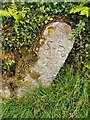
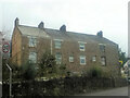
Mine boundary maker, Band House Land, Stenalees
Mine Boundary Marker on Band House Lane, Stenalees. Treverbyn parish. Inscribed S R / T perhaps for Singlerose china clay mine and Treverbyn.
Milestone Society National ID: CW_TREVER01em
Image: © R Fleet
Taken: 17 Jun 2021
0.02 miles
2
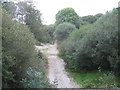
Dismantled railway
Looking northeast along the trackbed of a dismantled railway, from the overbridge on the minor road leading to Treverbyn.
Image: © Phil Williams
Taken: 9 Oct 2005
0.11 miles
3
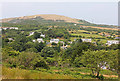
View over Stenalees
Looking over Stenalees from the OS Viewpoint.
Image: © Wayland Smith
Taken: 21 Jul 2013
0.14 miles
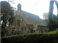
5
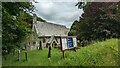
Church of St Peter
https://historicengland.org.uk/listing/the-list/list-entry/1289533?section=official-list-entry
Image: © Sandy Gerrard
Taken: 16 Jun 2024
0.19 miles
7
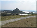
Clay Waste Tip
View of Penwithick Sky Tip from Carluddon Downs
Image: © bernard may
Taken: 9 Apr 2004
0.20 miles