IMAGES TAKEN NEAR TO
Singlerose Road, ST. AUSTELL, PL26 8TD
Introduction
This page details the photographs taken nearby to Singlerose Road, PL26 8TD by members of the Geograph project.
The Geograph project started in 2005 with the aim of publishing, organising and preserving representative images for every square kilometre of Great Britain, Ireland and the Isle of Man.

There are currently over 7.5m images from over14,400 individuals and you can help contribute to the project by visiting https://www.geograph.org.uk
Image Map
Images are licensed for reuse under creativecommons.org/licenses/by-sa/2.0
Notes
- Clicking on the map will re-center to the selected point.
- The higher the marker number, the further away the image location is from the centre of the postcode.
Image Listing (11 Images Found)
Images are licensed for reuse under creativecommons.org/licenses/by-sa/2.0
Image
Details
Distance
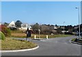
2
Stenalees : A391 Roundabout
A roundabout on the outskirts of Stenalees.
Image: © Lewis Clarke
Taken: 24 Mar 2013
0.08 miles
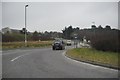
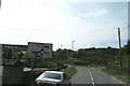
3
Roundabout at Stenalees
View from the B3274 where it meets the A391. The B road turns right, the A road enters from the left and continues straight ahead.
Image: © David Smith
Taken: 2 Jun 2011
0.08 miles
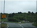
4
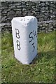
Old Milestone by the A391, south of Stenalees
Carved stone post by the A391, in parish of TREVERBYN (RESTORMEL District), South of Stenalees village, by new roundabout, on West side of road. Bodmin Roche stone, erected by the Bodmin & Roche turnpike trust in the 19th century.
Inscription reads:-
: B / 8 : : SᵗA / 3 :
Grade II listed.
List Entry Number: 1379512 https://historicengland.org.uk/listing/the-list/list-entry/1379512
Milestone Society National ID: CW_SABM03.
Image: © Rosy Hanns
Taken: 7 Apr 2019
0.09 miles
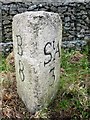
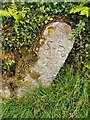
5
Old Milestone by the A391, south of Stenalees
Carved stone post by the A391, in parish of TREVERBYN (RESTORMEL District), South of Stenalees village, by new roundabout, on West side of road. Bodmin Roche stone, erected by the Bodmin & Roche turnpike trust in the 19th century.
Inscription reads:-
: B / 8 : : StA / 3 :
Carved bench mark and rivet on top.
Grade II Listed. List Entry Number: 1379512
https://historicengland.org.uk/listing/the-list/list-entry/1379512
Milestone Society National ID: CW_SABM03.
Image: © Ian Thompson
Taken: 10 Dec 2017
0.10 miles
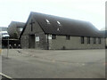
7

Stenalees former chapel
Near the roundabout recently renovated
Image: © Paul Barnett
Taken: 29 Oct 2015
0.17 miles
9

Clay Waste Tip
View of Penwithick Sky Tip from Carluddon Downs
Image: © bernard may
Taken: 9 Apr 2004
0.18 miles
10
Mine boundary maker, Band House Land, Stenalees
Mine Boundary Marker on Band House Lane, Stenalees. Treverbyn parish. Inscribed S R / T perhaps for Singlerose china clay mine and Treverbyn.
Milestone Society National ID: CW_TREVER01em
Image: © R Fleet
Taken: 17 Jun 2021
0.21 miles