IMAGES TAKEN NEAR TO
Nanpean, ST. AUSTELL, PL26 7YW
Introduction
This page details the photographs taken nearby to PL26 7YW by members of the Geograph project.
The Geograph project started in 2005 with the aim of publishing, organising and preserving representative images for every square kilometre of Great Britain, Ireland and the Isle of Man.

There are currently over 7.5m images from over14,400 individuals and you can help contribute to the project by visiting https://www.geograph.org.uk
Image Map
Images are licensed for reuse under creativecommons.org/licenses/by-sa/2.0
Notes
- Clicking on the map will re-center to the selected point.
- The higher the marker number, the further away the image location is from the centre of the postcode.
Image Listing (8 Images Found)
Images are licensed for reuse under creativecommons.org/licenses/by-sa/2.0
Image
Details
Distance
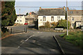
1
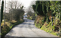
Road from Nanpean
It looks more rural looking away from Nanpean village down this lane. years ago there were far more clay driers and pits open then nowadays.
Image: © roger geach
Taken: 25 Nov 2011
0.11 miles
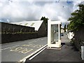
2
Junction on the corner on the B3279
Nanpean a clay village , sadly many of the claypits have shut so there is less employment in the clay industry then years ago.
Image: © roger geach
Taken: 25 Nov 2011
0.16 miles
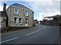
3
St Georges Road, Nanpean
The unusual bus shelter made is made from white stained wood. The industrial buildings opposite are part of the Drinnick china clay works.
Image: © David Gearing
Taken: 13 May 2014
0.19 miles
5
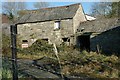
Derelict Buildings, Nanpean
These derelict buildings in the centre of the village have, according to the nearby sign, been "acquired for development".
Image: © Tony Atkin
Taken: 19 Nov 2005
0.21 miles