IMAGES TAKEN NEAR TO
St. Ewe, ST. AUSTELL, PL26 6HB
Introduction
This page details the photographs taken nearby to PL26 6HB by members of the Geograph project.
The Geograph project started in 2005 with the aim of publishing, organising and preserving representative images for every square kilometre of Great Britain, Ireland and the Isle of Man.

There are currently over 7.5m images from over14,400 individuals and you can help contribute to the project by visiting https://www.geograph.org.uk
Image Map
Images are licensed for reuse under creativecommons.org/licenses/by-sa/2.0
Notes
- Clicking on the map will re-center to the selected point.
- The higher the marker number, the further away the image location is from the centre of the postcode.
Image Listing (5 Images Found)
Images are licensed for reuse under creativecommons.org/licenses/by-sa/2.0
Image
Details
Distance
1
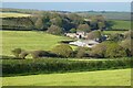
Farmland St Ewe
With cut silage fields to the west of Lanhadron Farm.
Image: © Andrew Smith
Taken: 25 Apr 2022
0.06 miles
2
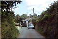
Cornish lane
A tight fit at Pengrugla.
Image: © Robert Ashby
Taken: 19 Aug 2014
0.23 miles
3
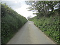
Route to Trelean
Typical example of a Cornish lane with passing bay.
Image: © Peter Holmes
Taken: 9 May 2014
0.24 miles
4
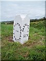
Old Guide Stone near Pengrugla, St Ewe parish
Guidestone by the UC road, in parish of St Ewe (Restormel District), near Pengrugla, on apex of Y-junction, on the verge.
Inscription reads:-
: GRAMPOND / AND / TREGONY : : MEVAGIS / SEY :
Grade II listed.
List Entry Number: 1327047 https://historicengland.org.uk/listing/the-list/list-entry/1327047
Surveyed
Milestone Society National ID: CW_XSTE3
Image: © Milestone Society
Taken: Unknown
0.25 miles
5
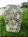
Old Guide Stone west of Pengrugla
Carved stone by the UC road, in parish of St Ewe (Restormel District), Pengrugla, on apex of Y-junction, on the verge.
Inscription reads:-
: MEVAGIS / SEY : : GRAMPOND / AND / TREGONY : : ST / AUSTELL :
Grade II listed.
List Entry Number: 1327047 https://historicengland.org.uk/listing/the-list/list-entry/1327047
Surveyed
Milestone Society National ID: CW_XSTE3
Image: © Rosy Hanns
Taken: 18 Apr 2019
0.25 miles