IMAGES TAKEN NEAR TO
School Hill, ST. AUSTELL, PL26 6DY
Introduction
This page details the photographs taken nearby to School Hill, PL26 6DY by members of the Geograph project.
The Geograph project started in 2005 with the aim of publishing, organising and preserving representative images for every square kilometre of Great Britain, Ireland and the Isle of Man.

There are currently over 7.5m images from over14,400 individuals and you can help contribute to the project by visiting https://www.geograph.org.uk
Image Map (Loading...)


Getting Data...Please wait
Leaflet Map data © OpenStreetMap
Images are licensed for reuse under creativecommons.org/licenses/by-sa/2.0
Notes
- Clicking on the map will re-center to the selected point.
- The higher the marker number, the further away the image location is from the centre of the postcode.
Image Listing (24 Images Found)
Images are licensed for reuse under creativecommons.org/licenses/by-sa/2.0
Image
Details
Distance

2
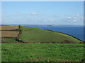
Coastal farmland, Mevagissey
Towards Mevagissey Bay.
Image: © JThomas
Taken: 5 Nov 2014
0.02 miles
3

Cliff Road approaching school, Mevagissey
Heading north.
Image: © JThomas
Taken: 5 Nov 2014
0.03 miles

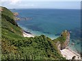
5
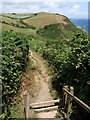
Coast path above Polstreath
The path crosses a stile to leave the built-up area north of Mevagissey and starts to descend towards the short but steep valley below Trewhinney. It can be seen climbing the far side above Penare Point.
Image: © Derek Harper
Taken: 3 Jul 2009
0.11 miles
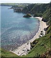
6
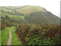
Coast path above Polstreath
The South West Coast Path descends and then ascends as it passes above Polstreath to the north of Mevagissey.
Image: © Philip Halling
Taken: 1 Oct 2010
0.14 miles
7
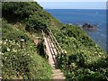
Footbridge near Polstreath
The bridge carries the coast path across the stream below Trewhinney. Just to the right is the scene shown in Image
Image: © Derek Harper
Taken: 3 Jul 2009
0.14 miles
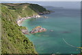
9
Polstreath
A reverse view of Image, looking along the full length of the beach at Polstreath to the stack that separates it from Image Mevagissey harbour can be seen further along the coast.
Image: © Derek Harper
Taken: 3 Jul 2009
0.16 miles
10
Polstreath
Like Image, and placing it a wider context, taken from the South West Coast Path. The rocks towards Penare Point on the left can also be seen in Image
Image: © Derek Harper
Taken: 3 Jul 2009
0.16 miles