IMAGES TAKEN NEAR TO
Trevarno Close, ST. AUSTELL, PL25 5SS
Introduction
This page details the photographs taken nearby to Trevarno Close, PL25 5SS by members of the Geograph project.
The Geograph project started in 2005 with the aim of publishing, organising and preserving representative images for every square kilometre of Great Britain, Ireland and the Isle of Man.

There are currently over 7.5m images from over14,400 individuals and you can help contribute to the project by visiting https://www.geograph.org.uk
Image Map
Images are licensed for reuse under creativecommons.org/licenses/by-sa/2.0
Notes
- Clicking on the map will re-center to the selected point.
- The higher the marker number, the further away the image location is from the centre of the postcode.
Image Listing (13 Images Found)
Images are licensed for reuse under creativecommons.org/licenses/by-sa/2.0
Image
Details
Distance
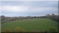
2
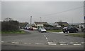
Trewoon : Meadow Park
Meadow Park in Trewoon heading off of the A3058.
Image: © Lewis Clarke
Taken: 24 Mar 2013
0.07 miles
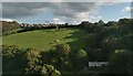
4
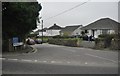
Trewoon : St Mewan Lane
St Mewan Lane as seen from the junction with the A3058.
Image: © Lewis Clarke
Taken: 24 Mar 2013
0.10 miles
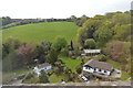
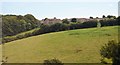
6
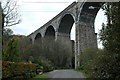
Railway Viaduct over the Gover Valley
This viaduct across the Gover Valley carries the mainline railway through Cornwall.
Image: © Tony Atkin
Taken: 19 Nov 2005
0.13 miles
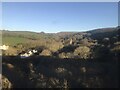
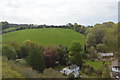
7
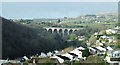
Gover Viaduct
Gover Viaduct, near St Austell, on the Cornish Mainline. In the background can be seen waste tips from the china-clay industry.
Image: © Duncan C Hill
Taken: 29 Dec 2007
0.13 miles