IMAGES TAKEN NEAR TO
The Crescent, ST. AUSTELL, PL25 4TA
Introduction
This page details the photographs taken nearby to The Crescent, PL25 4TA by members of the Geograph project.
The Geograph project started in 2005 with the aim of publishing, organising and preserving representative images for every square kilometre of Great Britain, Ireland and the Isle of Man.

There are currently over 7.5m images from over14,400 individuals and you can help contribute to the project by visiting https://www.geograph.org.uk
Image Map (Loading...)


Getting Data...Please wait
Leaflet Map data © OpenStreetMap
Images are licensed for reuse under creativecommons.org/licenses/by-sa/2.0
Notes
- Clicking on the map will re-center to the selected point.
- The higher the marker number, the further away the image location is from the centre of the postcode.
Image Listing (21 Images Found)
Images are licensed for reuse under creativecommons.org/licenses/by-sa/2.0
Image
Details
Distance
2
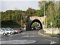
Under the Railway
The road takes a tunnel under the railway embankment in the Mount Charles district of St Austell.
Image: © Tony Atkin
Taken: 12 Nov 2005
0.09 miles
4
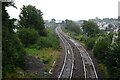
Railway near Alexandra Road
The Cornish Mainline east of St. Austell railway station. The rear of signal 5853 can be seen.
Image: © DS Pugh
Taken: 10 Sep 2024
0.10 miles
5
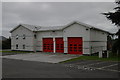
St Austell Fire Station
St Austell Fire Station, Carlyon Road, St Austell, Cornwall. Built to replace to old fire station on Bodmin Road (?) in the town centre (see Image).
Image: © Kevin Hale
Taken: 26 Sep 2004
0.11 miles
7
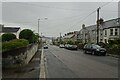
Alexandra Road
Looking along Alexandra Road in St. Austell on a wet evening.
Image: © DS Pugh
Taken: 10 Sep 2024
0.13 miles
9
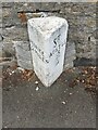
Old Milestone by Victoria Road, Mount Charles, St Austell
Carved stone post by the UC road, in parish of ST AUSTELL (RESTORMEL District), Victoria Road, by No.11, Mount Charles, half buried in pavement until 1992, on North side of road. Erected by a private estate in the 19th century.
Inscription reads:-
: PENRICE / 2 MILES : : ST / AUSTLE / 3/4 :
Grade II listed. List Entry Number: 1394421
Milestone Society National ID: CW_PCSA02.
Image: © Paul Barnett
Taken: 19 Jul 2018
0.15 miles
10
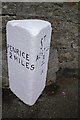
Old Milestone by Victoria Road, Mount Charles, St Austell
Carved stone post by the UC road, in parish of ST AUSTELL (RESTORMEL District), Victoria Road, by No.11, Mount Charles, half buried in pavement until 1992, on North side of road. Erected by a private estate in the 19th century.
Inscription reads:-
: PENRICE / 2 MILES : : ST / AUSTLE / 3/4 :
Grade II listed. List Entry Number: 1394421
https://historicengland.org.uk/listing/the-list/list-entry/1394421
Milestone Society National ID: CW_PCSA02.
Image: © Ian Thompson
Taken: Unknown
0.15 miles