IMAGES TAKEN NEAR TO
Trevear Close, ST. AUSTELL, PL25 4SL
Introduction
This page details the photographs taken nearby to Trevear Close, PL25 4SL by members of the Geograph project.
The Geograph project started in 2005 with the aim of publishing, organising and preserving representative images for every square kilometre of Great Britain, Ireland and the Isle of Man.

There are currently over 7.5m images from over14,400 individuals and you can help contribute to the project by visiting https://www.geograph.org.uk
Image Map (Loading...)


Getting Data...Please wait
Leaflet Map data © OpenStreetMap
Images are licensed for reuse under creativecommons.org/licenses/by-sa/2.0
Notes
- Clicking on the map will re-center to the selected point.
- The higher the marker number, the further away the image location is from the centre of the postcode.
Image Listing (11 Images Found)
Images are licensed for reuse under creativecommons.org/licenses/by-sa/2.0
Image
Details
Distance

5
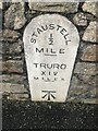
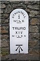
Old milestone on Alexandra Road 50 metres east of roundabout
National ID CW_TOSA14
Image: © Paul Barnett
Taken: 19 Jan 2023
0.21 miles
6
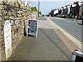
Old Milestone in Alexandra Road, St Austell
Carved stone post by the A390, in parish of ST AUSTELL (RESTORMEL District), Alexandra Road, by No. 10, built into garden wall, on North side of road. Erected by the St Austell & Lostwithiel turnpike trust in the 19th century.
Inscription reads:-
ST.AUSTELL
½
MILE
TRURO
XIV
MILES
Large benchmark at base of front face.
Grade II Listed. List Entry Number:1407574
https://historicengland.org.uk/listing/the-list/list-entry/1407574
Milestone Society National ID: CW_TOSA14.
Image: © Ian Thompson
Taken: 23 Apr 2009
0.22 miles
7
Old Milestone in Alexandra Road, St Austell
Carved stone post by the former A390, in parish of ST AUSTELL (RESTORMEL District), Alexandra Road, by No 10, built into garden wall, on North side of road. Erected by the St Austell & Lostwithiel turnpike trust in the 19th century.
Inscription reads:-
Sᵀ.AUSTELL
½
---
MILE
TRURO
XIV
MILES
---
Large benchmark at base of front face.
Grade II listed.
List Entry Number: 1407574 https://historicengland.org.uk/listing/the-list/list-entry/1407574
Milestone Society National ID: CW_TOSA14.
Image: © Rosy Hanns
Taken: 13 Apr 2019
0.22 miles

10
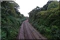
Railway approaching Carlyon Road
The Cornish Mainline east of St. Austell railway station. The line is bidirectionally signalled with signal 5855 on ahead.
Image: © DS Pugh
Taken: 10 Sep 2024
0.24 miles